
Image credit: ASU/Purdue University, Bedrich Benes and Michel Abdul-Massih
One of the first steps in tackling climate change is to curb greenhouse-gas emissions. The trouble is, both the public and policymakers have been slow to act on a problem they cannot physically see.
It's easy to blame harmful emissions on China, coal companies or the next-door neighbor. But people would likely do more to reduce their carbon footprint if they could visualize the damage they are doing.
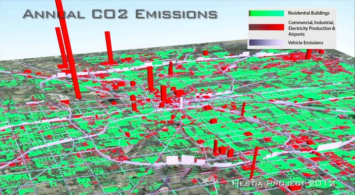
Historically, scientists have measured greenhouse gases, such as carbon dioxide (CO2), on a broad scale. But now, researchers at Arizona State University (ASU) and Purdue University have developed a new model to track CO2 emissions on a much smaller scale, right down to the street level. In fact, the software program is so detailed that it can zero in on the level of CO2 emissions emitted by each individual building.
The system, named "Hestia" after the Greek goddess of hearth and home, combines data from local air-pollution reports, traffic simulations and individual buildings' energy consumption, and feeds it into a sophisticated modeling program to determine CO2 emissions at the street and building level.
The result is a color-coded map of greenhouse-gas emissions, right down to the building level. The researchers hope that by quantifying and visualizing cities' CO2 emissions at such a detailed level, the software model will encourage consumers and businesses to reduce their consumption and carbon footprint.
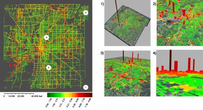
Image credit: ASU/Purdue University, Bedrich Benes and Michel Abdul-Massih
Global climate change
So far, the program has only been used to track emissions in Indianapolis, but the researchers are already working on mapping data for Los Angeles and Phoenix, and they plan to eventually apply it to all major U.S. cities, which together account for nearly one-quarter of total global CO2 emissions, according to the researchers.
The hope is that Hestia will influence how not only cities, but nations invest in energy and work toward being more sustainable. In fact, if applied on a larger scale, the computer model has the potential to change global leaders' attitudes toward climate change.
The concept may be especially critical in the U.S., which has historically shied away from climate-change treaties such as the Kyoto Protocol, which set binding targets for reducing greenhouse-gas emissions.
Putting an image to the damage could be just what it takes to incent change, both at the community level and on the global stage.
"These results may also help overcome current barriers to the United States joining an international climate-change treaty," explains Kevin Gurney, an associate professor in ASU's School of Life Sciences, senior scientist with the Global Institute of Sustainability and Hestia's lead scientist. "Many countries are unwilling to sign a treaty when greenhouse-gas emission reductions cannot be independently verified."
Hestia is just one part of a larger effort to measure greenhouse-gas emissions at both the ground and satellite levels. It was designed to complement NASA's December 2013 launch of a satellite that will measure CO2 emissions in the Earth's atmosphere.