Scroll down for older installments.
Update -- 06:50pm EST Monday, 10/29/2012
* This will be the last Alerts Broadcaster update before Sandy comes ashore this evening, about 2-3 hours earlier than thought, and even stronger than models were predicting yesterday, but otherwise things are pretty much on-target.
* I may issue one more update overnight, again first thing Tuesday. For the last week we've been focused on pinpointing the storm's track and severity. Our specialty is looking ahead -- you'll be able to get damage reports and updates from every media (and blog) source on the planet, including my friends at The Huffington Post. Clean-up and recovery efforts will continue to be a big story well into November.
Hurricane Sandy Headlines:
...SANDY MOVING MORE QUICKLY TOWARD SOUTHERN NEW JERSEY...
...LANDFALL EXPECTED EARLY THIS EVENING...
SUMMARY OF 200 PM EDT...1800 UTC...INFORMATION
----------------------------------------------
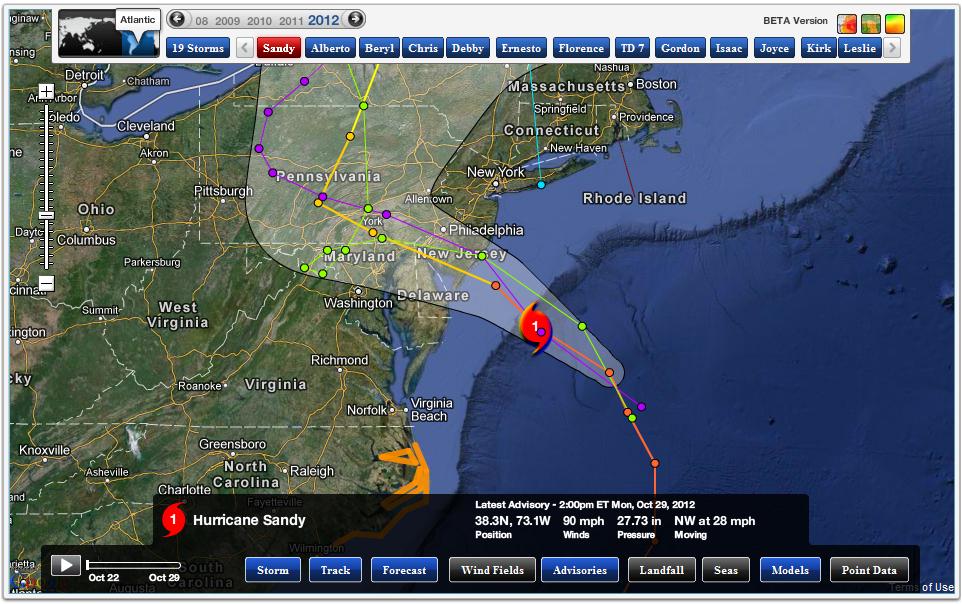
LOCATION...38.3N 73.1W
ABOUT 110 MI...180 KM SE OF ATLANTIC CITY NEW JERSEY
ABOUT 175 MI...285 KM SSE OF NEW YORK CITY
MAXIMUM SUSTAINED WINDS...90 MPH...150 KM/H
PRESENT MOVEMENT...NW OR 305 DEGREES AT 28 MPH...44 KM/H
MINIMUM CENTRAL PRESSURE...940 MB...27.76 INCHES
I realize there was (a lot) of skepticism, cynicism and name-calling with this storm. "Meteorologists are hyping the weather again!" Americans were understandably hesitant about taking Sandy seriously, in spite of repeated warnings. As I tell my staff at The Media Logic Group, it's good to be skeptical, but perpetual cynicism in the face of overwhelming evidence isn't good -- in fact it can be dangerous. The prevailing wisdom for many coastal residents was: "I'll believe it when I see it, and if it gets bad...we can always leave at the last minute!" Maybe not. Because at the last minute roads and bridges may be inundated, barrier islands cut off. You'll have no choice but to ride out the storm. Emergency management and 911? In spite of best efforts they may not be able to reach your location in time.
Synopsis. Sandy's 90-100 mph. winds will reach coastal New Jersey this evening. Winds in New York and Long Island will gust to 90 mph, with a second, even stronger, more damaging storm surge late this evening, coinciding with high tide and a full moon. Astronomical forces have conspired to turn this from a one in 50 year storm to a one in 100 year storm surge for many coastal locations.
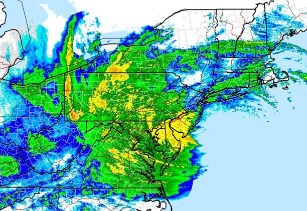
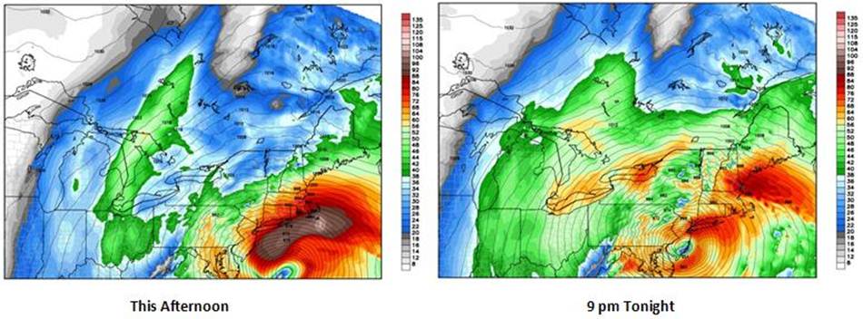
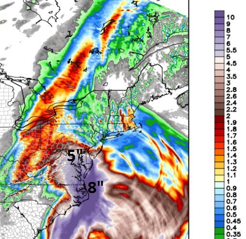
Monster-Storm. As expected the heaviest rains and reports of inland flooding are taking place from south Jersey, the Delaware Valley and southern Pennsylvania south to D.C., Baltimore, the Delmarva Peninsula (Bethany Beach and Rehoboth) and Virginia's Tidewater into OBX. Rainfall amounts may exceed 2-4" over southern New England, but inland flooding will be worse over the Mid-Atlantic than over most of New England.
The second, most damaging storm surge takes place close to landfall and high tide tonight, between 8 pm and midnight at many locations. This will be the height of the storm, in terms of wave-power and inundation of low-lying areas -- as bad as it gets.
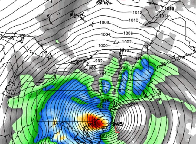
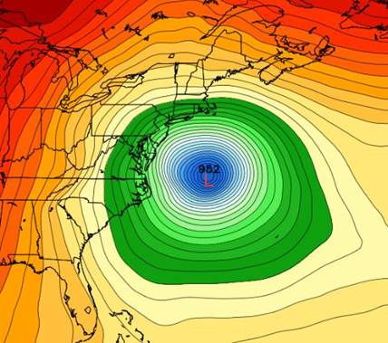
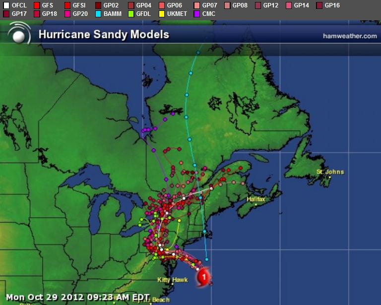
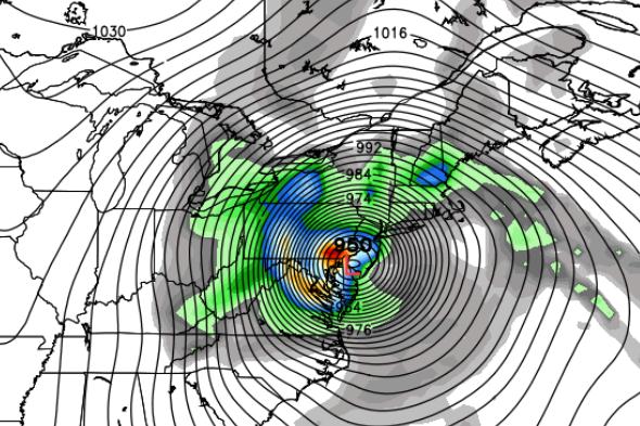
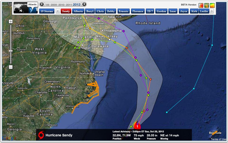
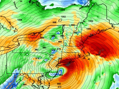
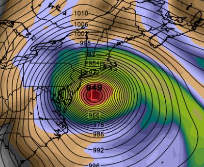
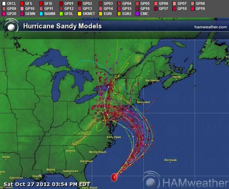
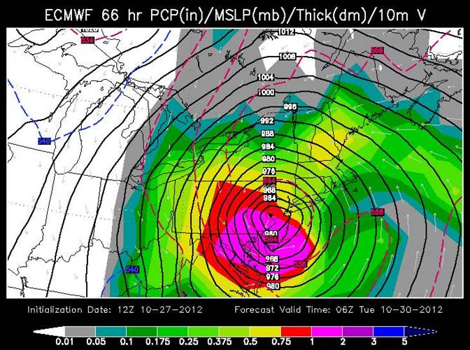
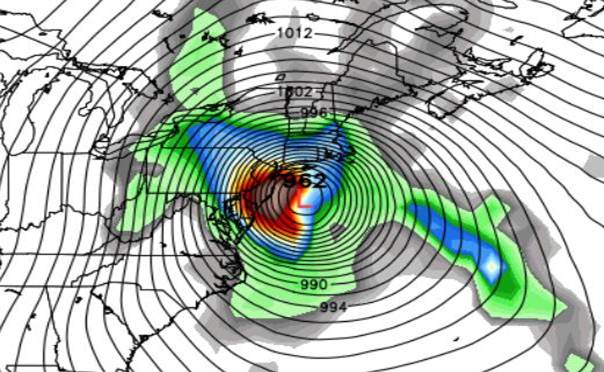
Sandy Accelerating Inland. Although (on paper) a Category 1 hurricane -- Nor'easter hybrid, factoring high tides and a full moon, Sandy may have the impact of a strong Category 2 hurricane, especially from coastal Delaware northward to Connecticut. Map above: Ham Weather.
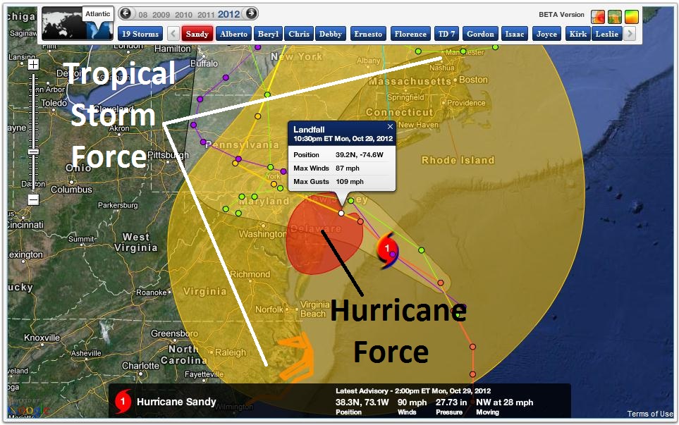
A Storm Like No Other. I've been tracking weather since Tropical Storm Agnes flooded my home in Lancaster, Pa in 1972. In the 40 years I've been subsequently studying and practicing meteorology I have never seen a storm with a wind field this extensive and severe, impacting more Americans at one time. Tropical storm force winds are in yellow, hurricane force winds are the red bulls-eye, stretching from Ocean City, Maryland northward to Asbury Park, New Jersey. Winds in New York will exceed hurricane force early tonight. Map: Ham Weather.
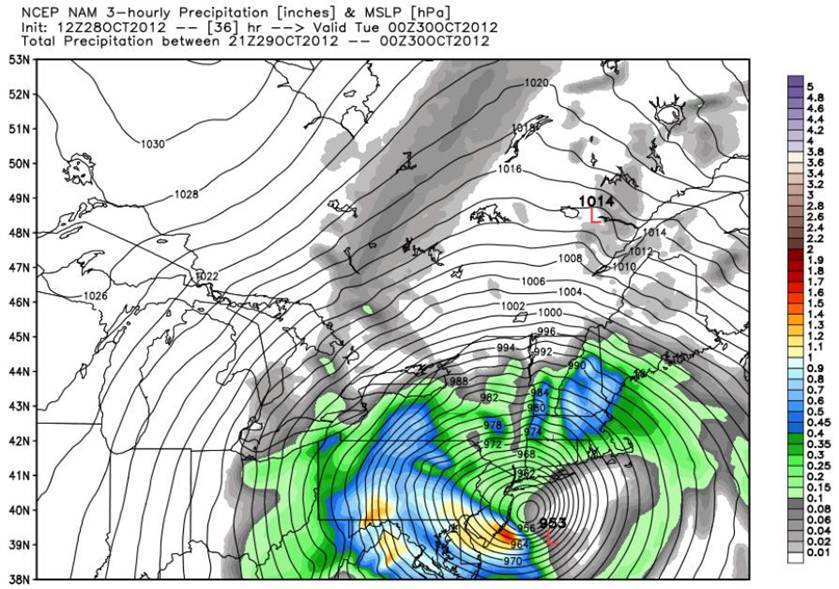
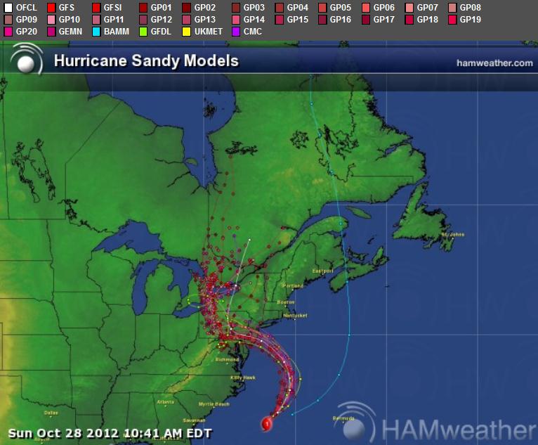
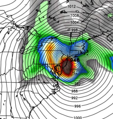
Landfall Imminent. The latest 12km NAM model shows landfall this evening near Atlantic City between 6-8 pm, Sandy moving almost due west, blocked from veering out to sea by a blocking high pressure system over the North Atlantic. Map above: Weather Bell.
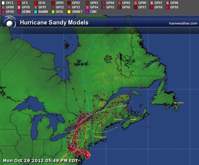
Model Ensemble. The soggy remains of Sandy will track right over Philadelphia this evening (possibly maintaining hurricane strength into the Delaware Valley), then weaken rapidly as it curves northwestward over State College, before accelerating up the St. Lawrence Valley. A strong differential in air pressure will keep tropical storm force (39 mph plus) winds into midday Wednesday across much of the Northeast. Map above: Ham Weather.
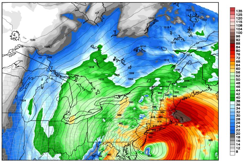
Model Alignment. There is little doubt that south Jersey will experience a direct strike, with sustained winds of 90-95 and gusts as high as 115. In addition to bringing down trees and power lines, stronger (sustained) winds will serve to carve out a higher storm surge from coastal New Jersey northward to Long Island Sound later this evening. Map: weather@sfwmd.gov.
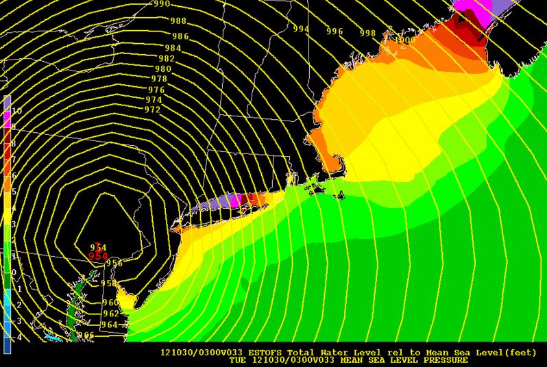
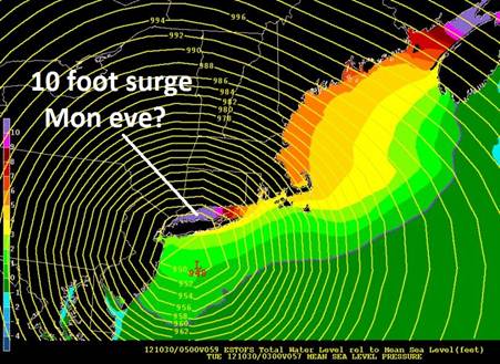
Maximum Surge. Still reeling from a 6-12 foot surge late morning and midday, a second, slightly higher surge if forecast for late evening from northern New Jersey and "The New York Bight", northeastward to Groton, CT. Based on a track across southern New Jersey, sustained wind speed/direction and underwater topography (Continental Slope) a 10 foot plus storm surge is anticipated in western Long Island Sound, impacting Long Island, Greenwich, CT, and portions of Queens and Brooklyn. Map: NOAA.
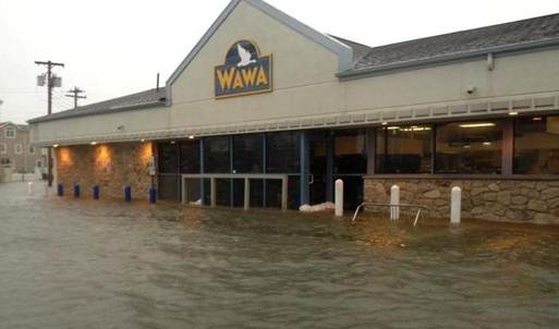
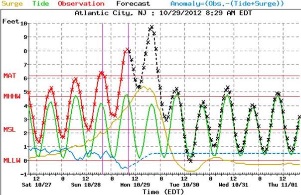
Impact Of First Storm Surge. This photo, courtesy of WeatherNation TV, was taken in Atlantic City around midday when an 8 foot surge was reported. A second surge is likely, coinciding with landfall and high tide this evening.
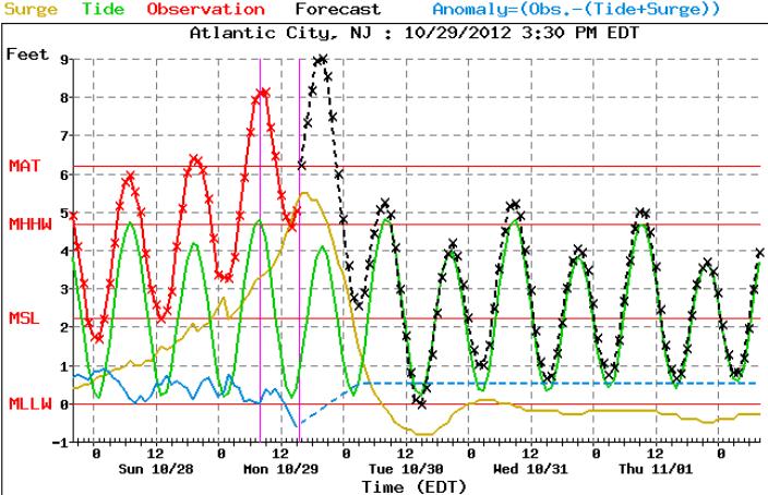
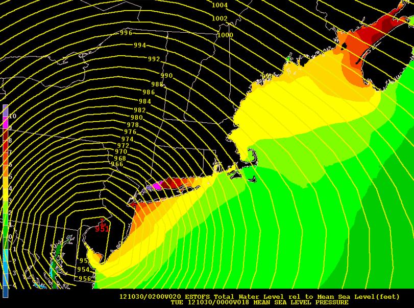
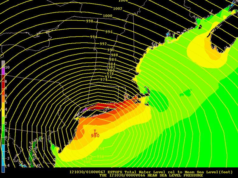
Atlantic City. If anything the "Slosh" models underestimated flooding for coastal New Jersey. The observed surge is in red, a slightly higher, second severe surge is likely by 9 pm EDT along the Jersey Shore. Storm Surge Prediction Graph above: NOAA.
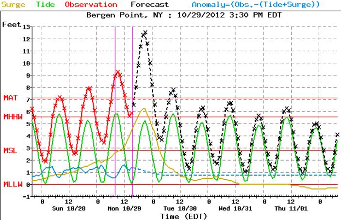
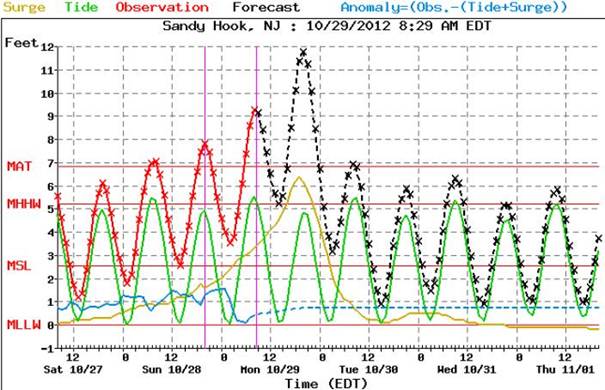
New York Harbor: Getting Worse Before Conditions Improve Tuesday. A maximum surge of 9 feet was reported at Bergen Point, New York earlier today. Tonight's surge, coming between 8 pm and 11 pm, may be 12-13 feet above normal sea level.
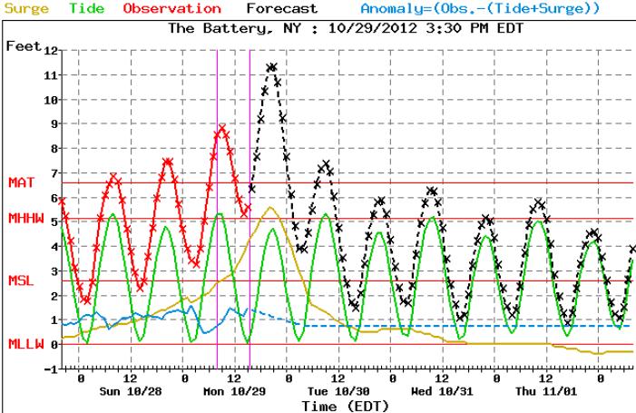
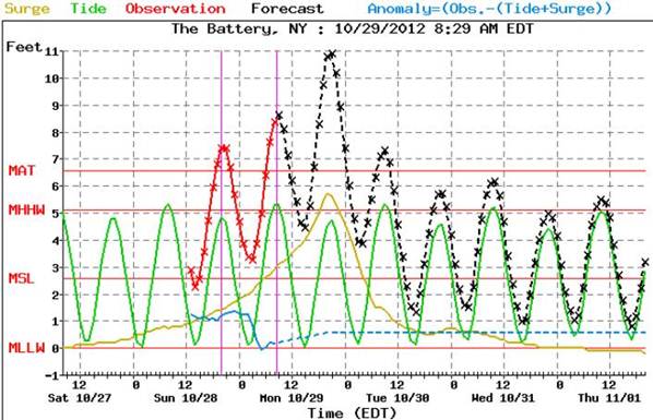
A Flooded Battery. This morning's 9 foot (observed) storm surge at Manhattan's Battery was a taste of what's to come -- an 11-12 foot surge, marking the peak of the storm, rolls into Lower Manhattan between 8 and 10 pm. This should be as bad as it gets -- and it will be pretty bad.
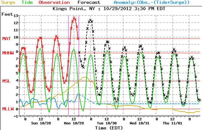
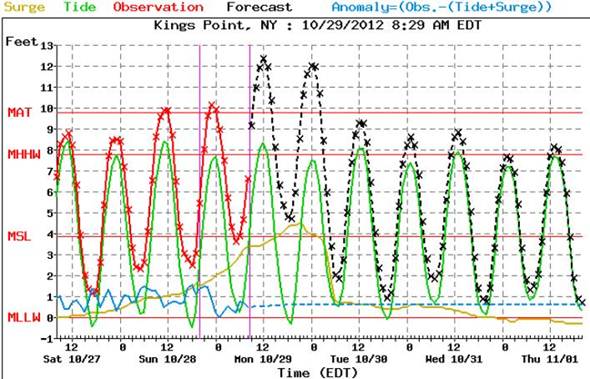
Kings Point, New York. Located just east of LGA, Kings Point already experienced a major surge of 12.7 feet above normal sea level. A second surge late this evening will be comparable, probably exceeding 12 feet. I suspect there won't be many flights leaving from La Guardia or JFK until later this week.
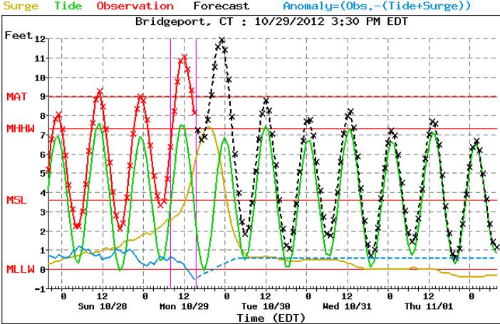
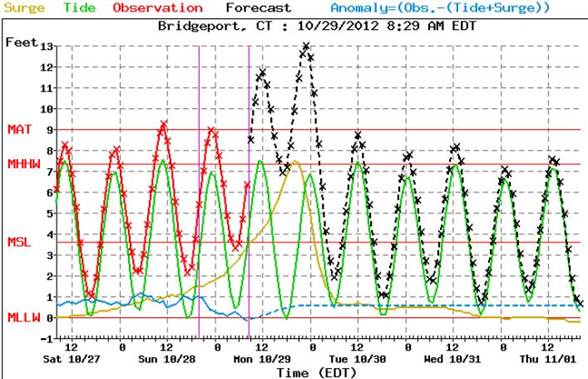
Severe Coastal Flooding For Connecticut. Bridgeport, CT experienced an 11 foot surge shortly before noon; tonight's surge (between 9 pm and midnight) may reach 12 feet.
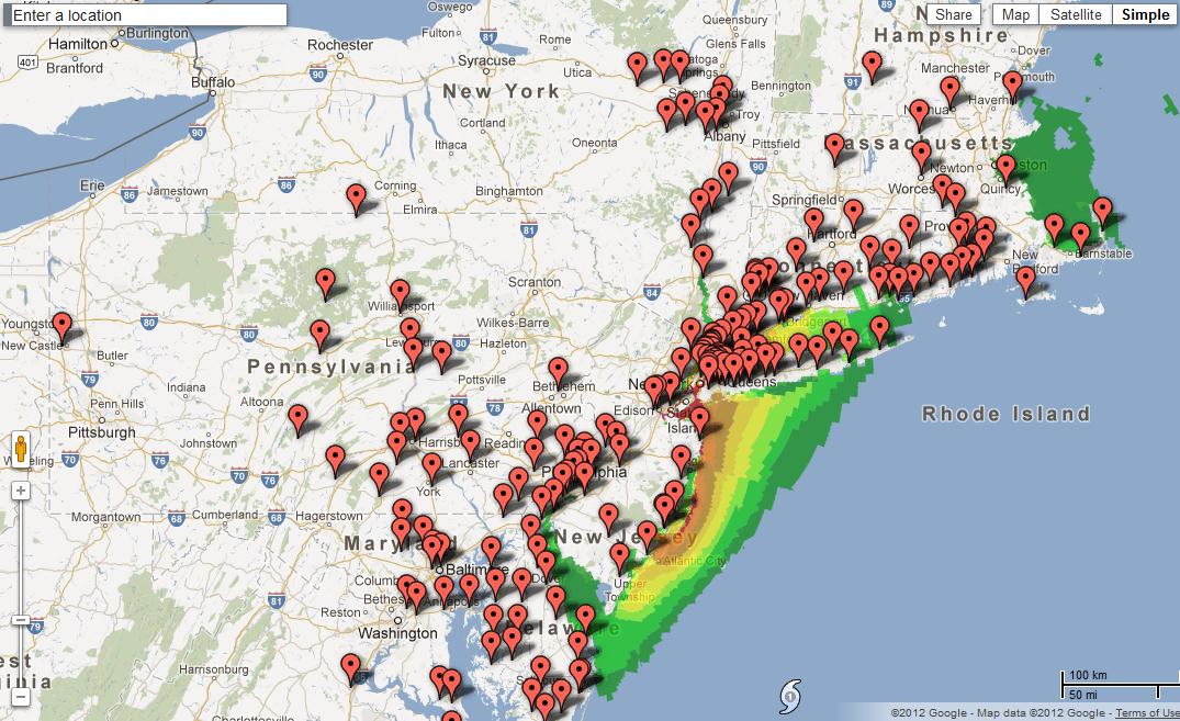
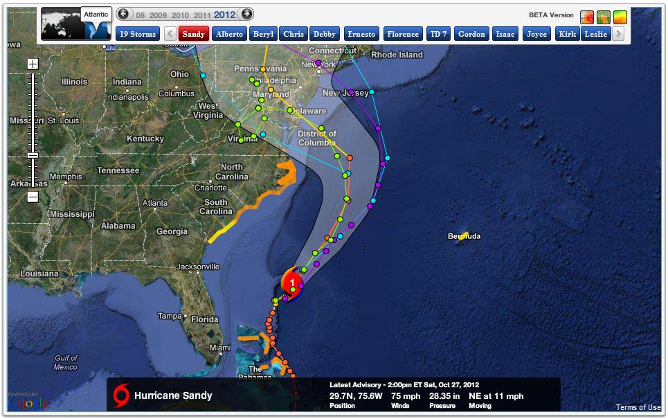
Storm Shelters. An interactive map from Google shows the location and status of emergency shelters opening up from the Outer Banks to coastal New England.
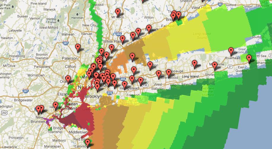
Surge + Shelter Information. Here is a close-up of the same Google tool, centered on New York and Long Island. Storm surge information is superimposed.
Meteorological "Bomb." Meteorologists are (at time) prone to exaggeration and hype. But, if anything, we may have slightly undersold this storm. Every storm is different, every hurricane is unique. Weather models help, as does experience, past history and gut feel. There have been similar storms over the ages, but nothing quite like "Sandy", in terms of a). coming so late in the season, b). the size of the storm, c). the slow forward motion of the storm, and d). astronomical complications: high tide coupled with a full moon magnifying subsequent storm surges. We said this was going to be an historic storm -- and events are playing out to underscore this prediction. Sandy has been a vivid reminder that America's weather is, in fact, becoming more extreme.

Hurricane Sandy from NASA's ISS, International Space Station, 260 miles above the ground.
Lessons of Sandy. According to my friend, Jeff Masters at The Weather Underground, the last 2 years have been the most severe in America's history, dating back to 1816. Many of the storms we've been tracking since 2010 have been slower... and far more intense than anything I can remember 30-50 years ago.
Alerts Broadcaster was launched last year to provide America's leading companies with timely guidance, attempting to provide an extra safety margin for corporations determined to leverage new technologies and meteorological expertise and briefing services -- to provide an additional safety level for staff and customers, a few extra days in the case of hurricanes and major winter storms (or hours, in the case of tornadoes, wildfires and flash floods) to safeguard facilities and maximize preparedness. We can't change the weather -- but we can take steps to harness new technologies, location-aware GPS-alerting and advanced briefing services, to increase safety margins and operate more efficiently...and safely.
I want to thank our valued Alerts Broadcaster clients, prospects and Huffington Post readers who have taken Alerts Broadcaster for a trial run this past week. I hope these updates were of value in your planning for Sandy.
I also hope that you and your families, friends and business colleagues ride out Sandy safely tonight. Conditions begin to improve tomorrow, with winds finally subsiding below tropical storm thresholds Wednesday.
Another intermediate update late tonight, after Sandy is inland -- one more post-storm wrap-up Tuesday morning.
Update -- 01:20pm EST Monday, 10/29/2012
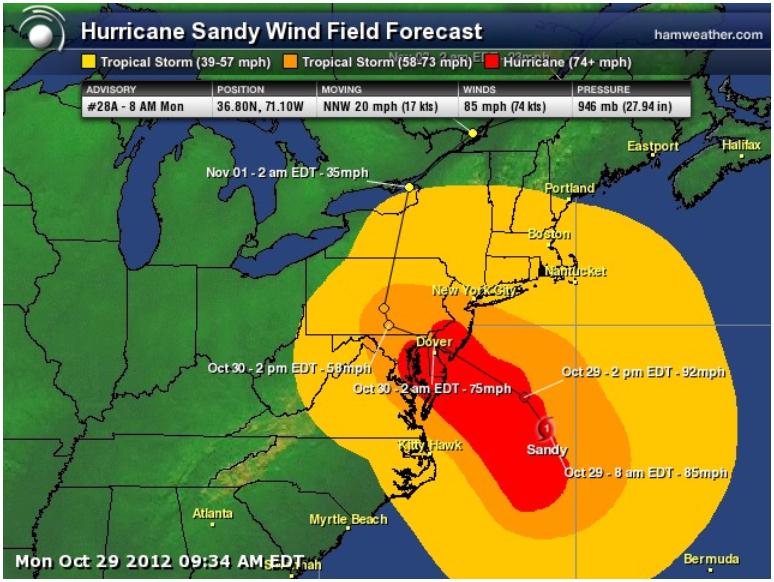
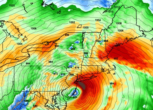
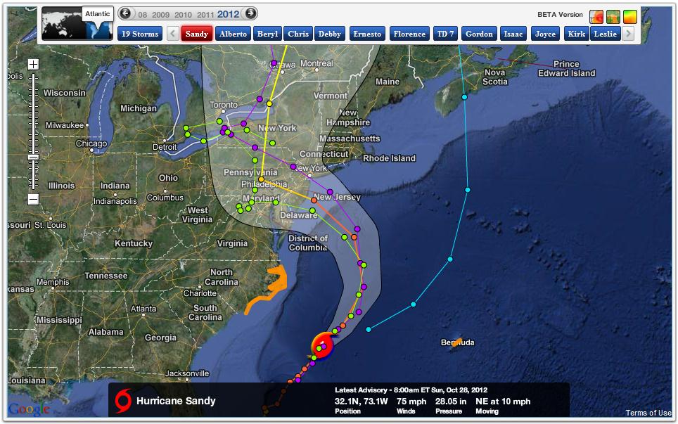
Hurricane-Nor'easter Sandy Still On Track To Deliver Punishing Blow. It's tempting to look at a Category 1 hurricane and think "no big deal -- we've seen worse." But it's a combination of factors, meteorological, geographical and astronomical, that will make Sandy (much) more than a minor inconvenience from today into Tuesday. Latest model guidance suggests that winds won't subside below tropical storm force in New York City until Wednesday morning. This is a long-duration, high-impact storm. Based on 12z guidance (above) peak winds are forecast to come this afternoon and evening, some (slight) easing of winds by late evening as Sandy comes ashore near Atlantic City. Important: the storm is actually stronger, deeper, with lower pressure than predicted by the models yesterday at this time. Peak sustained winds have increased from 75 mph early Sunday to 90 mph (now), with gusts over 100 mph.
Latest from NHC:
SUMMARY OF 1100 AM EDT...1500 UTC...INFORMATION
-----------------------------------------------
LOCATION...37.5N 71.5W
ABOUT 205 MI...330 KM SE OF ATLANTIC CITY NEW JERSEY
ABOUT 260 MI...415 KM SSE OF NEW YORK CITY
MAXIMUM SUSTAINED WINDS...90 MPH...150 KM/H
PRESENT MOVEMENT...NNW OR 330 DEGREES AT 18 MPH...30 KM/H
MINIMUM CENTRAL PRESSURE...943 MB...27.85 INCHES
Monday Midday Headlines:
At last report Sandy was packing 90 mph winds with gusts over 100 mph - a central pressure of 27.85", even deeper/stronger than some computer models were predicting yesterday.
The next 12-24 hours will be critical; Sandy comes ashore tonight, but two surges of water, magnified by high tide and a full moon, will sweep ashore - later this morning and midday, a second, slightly higher surge predicted for late evening. That is risk #1. Winds will be a factor, bringing down tree limbs and subsequently power lines, plunging millions (potentially) into darkness. People need to be prepared and ready for an extended period of time without power. Inland flooding will be another problem, especially from Philadelphia and Harrisburg to Washington D.C, Baltimore, Annapolis and the Delmarva Peninsula. If you've been flooded by a previous hurricane or tropical storm you'll probably see significant flooding from Sandy.
Conditions will slowly improve Tuesday, but tropical storm force winds may not die down until a Wednesday time frame.
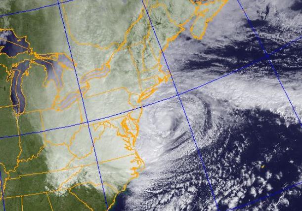
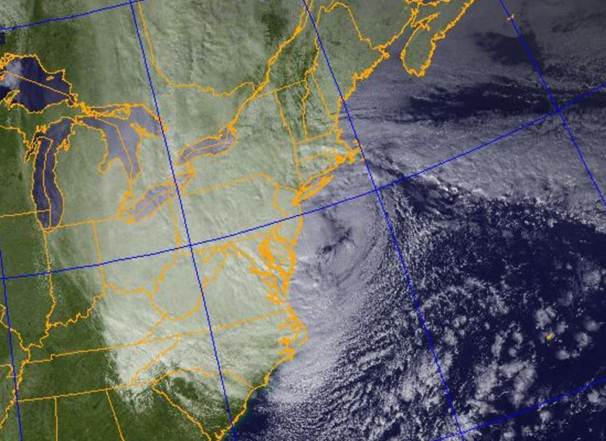
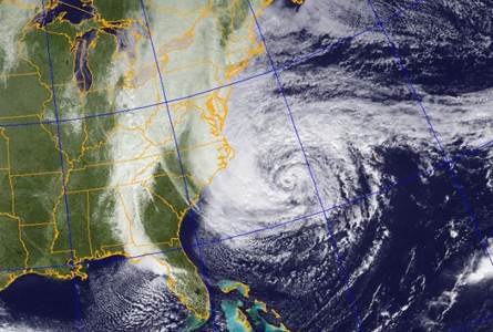
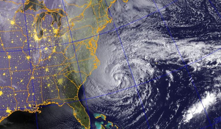
Midday Satellite. The NRL, Naval Research Lab, published this photo of Sandy early Monday morning, evidence of a sprawling high pressure bubble to the north which is blocking the storm from racing northeastward, out to sea - forcing it to detour inland, with landfall still scheduled for tonight.
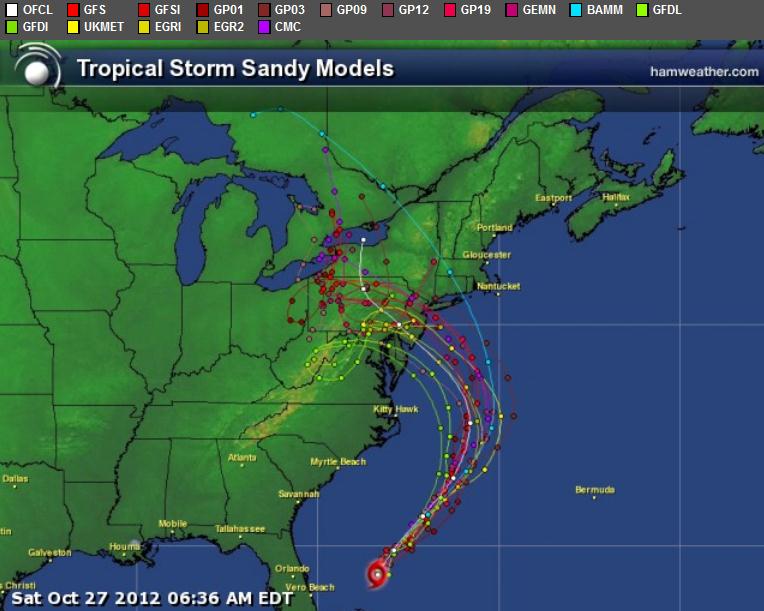
One Massive Storm. I can't remember (ever) seeing a storm impacting such a broad area in my 35 year career. Based on NOAA and NHC guidance here is the cone of hurricane vs. strong tropical storm vs. tropical storm winds. Map courtesy of Ham Weather.
Model Alignment. This is what should happen, over time - the models gradually center on one track solution, and right now the vast majority of computer simulations bring Sandy ashore late tonight over south Jersey or (possibly) the Delaware coast. Map: Ham Weather.
Consensus. As you can see (above) there is strong agreement on the track of Sandy, special emphasis given to ECMWF and GFS solutions, but there's little disagreement about possible detours and wobbles. Map source here.
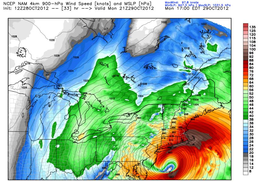
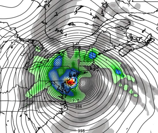
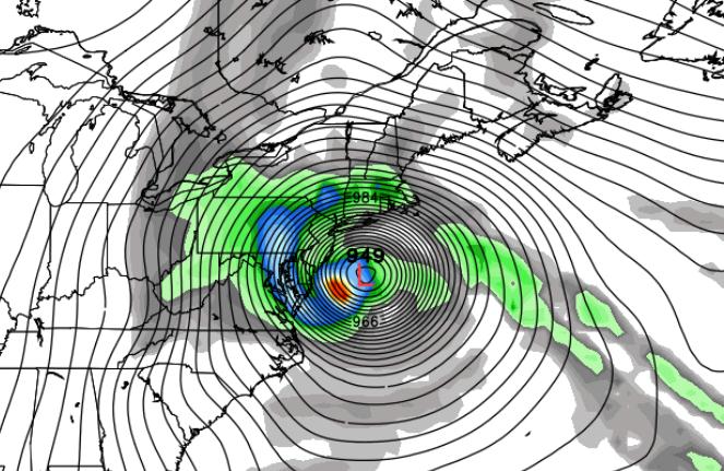
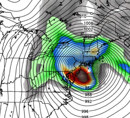
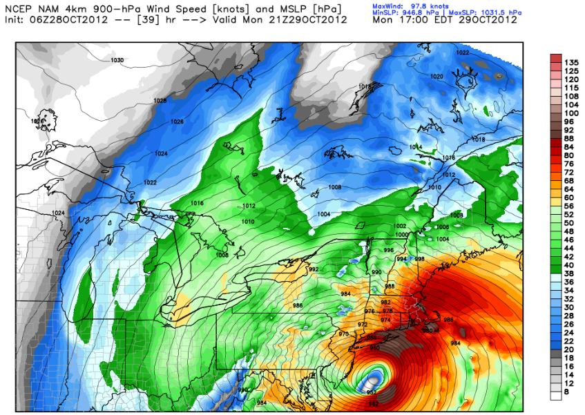
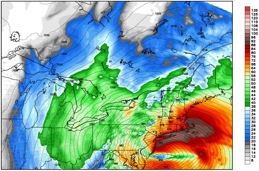
Landfall. The 4 km. NAM model shows landfall around 11 pm tonight near Atlantic City, with the strongest wind field 60-110 miles north of the center of low pressure, passing right over Long Island and metro New York City. Map above is for wind speeds at 900 mb, about 1,500 feet aloft, showing gusts approaching 100 mph near Southampton, Long Island - some of this high-velocity air will work down to the ground. Expect sustained winds of 65-85 mph in New York, with gusts in the 90-95 mph range, with the peak of the storm coming tonight. Model guidance: Weather Bell.
ECMWF Solution. The European model was the first to show Sandy hooking inland (last Sunday we sent up a flare to clients warning them of this possibility). The latest ECMWF solution shows landfall near Atlantic City or Wildwood between 9-11 pm tonight. Map above: WSI Corporation.
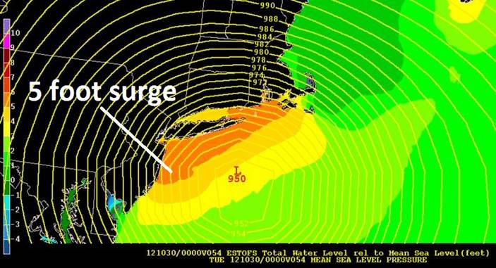
GFS Solution. On a very similar track, the U.S. GFS model shows landfall closer to Wildwood or Cape May. It's a (very) good thing that New Jersey's barrier islands have been evacuated - a high probability of a 5-9 foot storm surge coming ashore by this evening.
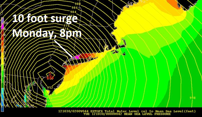
Storm Surge: 11 pm (Eastern) Tonight. NOAA's "Slosh" models show the peak storm surge coming around 11 pm tonight, as high as 10 feet in Long Island Sound, coinciding with predicted wind speed and direction, underwater geographical formations (Continental Slope), high tide and a full moon. One surge comes late this morning, coinciding with high tide, a second (slightly higher) surge arrives before midnight tonight, when the most severe flooding may occur across the boroughs of New York, Long Island and coastal Connecticut. Image link here.
Atlantic City. NOAA's Slosh models show a peak surge as high as 9 feet between 6-9 pm this evening. Surge forecasts courtesy of NOAA.
Sandy Hook, New Jersey. Peak storm surge in northern New Jersey comes between 6-9 pm, water funneling into the "New York Bight" causing potentially severe flooding.
The Battery: Manhattan. A peak storm surge of 10-11 feet is predicted around 9 pm tonight, coinciding with high tide and a full moon. This will bring very substantial water into Lower Manhattan -- areas that flooded in the past will flood later today.
Kings Point, New York. Located on the northern shore of Long Island, just east of La Guardia, Kings Point shows two major storm surges, one around noon today, a second this evening at 6-7 pm, both surges may approach 12 feet.
Bridgeport, CT. NOAA Slosh guidance shows an 11-12 foot surge by midday today, an even higher surge between 5-8 pm this evening approaching 13 feet. Low-lying areas from Greenwich to Stamford, Westport and New Haven will see low-level inundation.
Providence, Rhode Island. A peak surge is predicted around 9 pm to midnight, exceeding 9 feet.
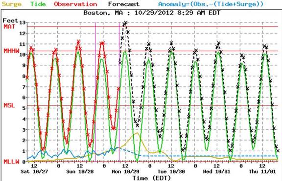
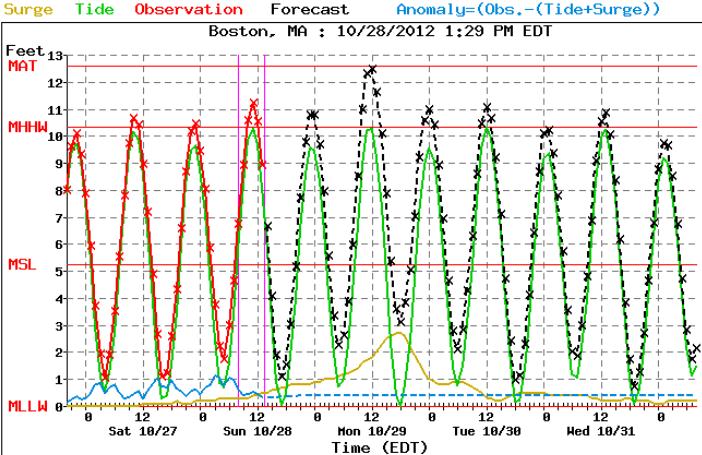
Boston. A peak surge at Boston is predicted for midday today, close to 13 feet above (normal) sea level.
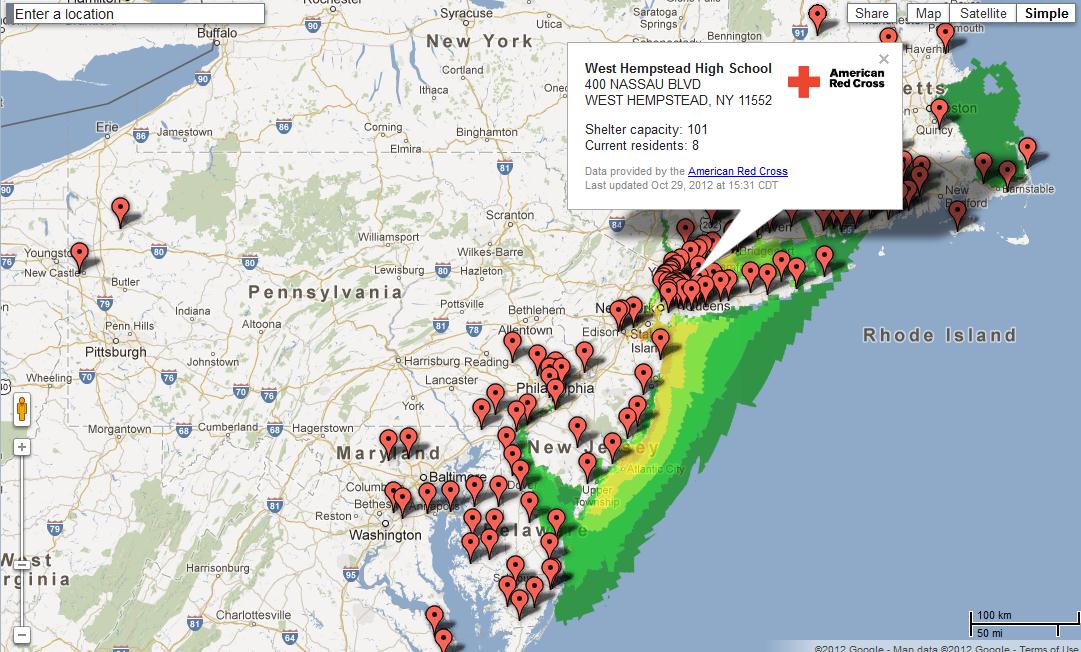
Resources. Google has published a useful link showing maximum storm surge forecasts overlaid with Doppler radar, storm track, and the location of emergency shelters from Virginia's Tidewater northward to Boston.
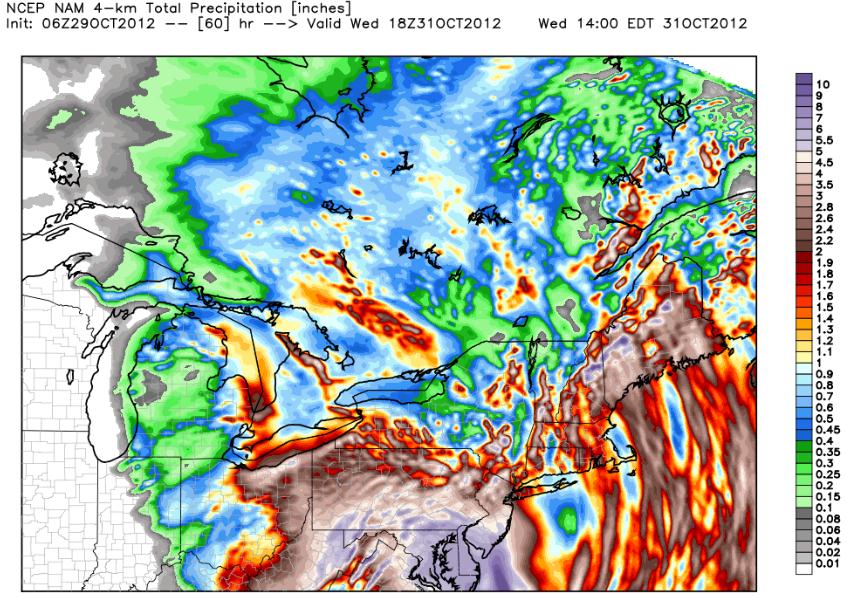
Inland Flooding Potential. Hampton City, VA. has already been inundated with over 9" rain, over 7" at Kill Devil Hills, North Carolina (OBX) and over 6" at Virginia Beach. The map above (4 km. NAM model) shows total rainfall with Sandy, with the heaviest amounts predicted from the Delmarva Peninsula westward to D.C. and Baltimore, north into the Delaware Valley, Lancaster, York and Harrisburg. Flash flooding is likely in these areas, but one minor silver lining: rainfall amounts will not be as heavy over southern New England.
An 18th Century Tuesday For Millions of Americans? An engineer at John Hopkins University has predicted power outages, based on Sandy's characteristics and track. Here is an excerpt of his study: "Using a computer model based on a current forecast as well as data from past hurricanes, an engineer at The Johns Hopkins University predicts that 3 million people in New Jersey will lose power during Hurricane Sandy. Pennsylvania will follow closely behind with 2.5 to 3 million people predicted to lose power, and Maryland with 1.8 million people predicted to lose power. Washington, D.C., and Delaware will have fewer outages, with 200,000 and 400,000 people predicted to lose power, respectively."
Summary: The (super) storm we've been tracking and warning of for nearly a week is now approaching. Final contingency plans should be rushed to completion. The height of the storm comes tonight, but the first (major) storm surge arrives late morning and midday, starting with the New Jersey coastline. The storm is tracking (very) slight farther south of New York City than models were suggesting yesterday, but our team still expects a major storm surge for Long Island Sound, inundating low-lying areas of Brooklyn and Queens (including some of the runways at JFK and LGA). Lower Manhattan will see substantial flooding at high tide, later this morning, again late evening. Inland rains will create flash flooding capable of shutting down even major highways, but rainfall amounts won't be quite as severe from New York to Boston. It's hunker-down time, venturing outside to drive (or shoot video/photos) a fairly bad idea from D.C. to Boston today.
Some level of property damage in high impact areas is inevitable -- right now the priority is lowering the risk to people in the path of Sandy. If local residents living within 10 feet of water can't evacuate inland, or to higher ground, the next best option is a vertical evacuation, riding out the storm in a 3rd or 4th floor building.
Another update late this afternoon as new guidance arrives and Sandy approaches the New Jersey coastline.
Good luck.
Update -- 05:40pm EST Sunday, 10/28/2012
Alerts Broadcaster Update: A potential one in 100 year storm is still on track to deliver a punishing blow on Monday, from coastal Delaware and New Jersey to New York, Long Island, Cape Cod and Boston Harbor. Little has change in the last 8-12 hours, if anything the computer models we've been studying since Sunday are coming into even closer alignment.
Impacts from Sandy (listed in rough order of priority, in terms of damage potential and number of people/companies impacted):
1). Storm surge: we expect the worst storm surge flooding out ahead of Sandy to take place late morning, again late evening on Monday, coinciding with high tide (and a full moon Monday PM hours). Tides are already 2-3 feet higher than average due to astronomical conditions -- Sandy's sustained winds and low pressure (28.25") will create a dome of water that will be pushed ashore in two major surges: 9am -- noon, again 9pm -- midnight Monday.
2). Winds: sustained winds of 50-75 mph are likely in a 300 mile swath Monday and Monday night, the strongest winds over southern New England and Long Island Monday PM hours, with gusts over 90 mph at times. There will be wind damage, downed trees and power lines -- I expect a rash of power outages. Companies with well-maintained generators will be glad they made that investment by midday Monday.
3). Inland flooding. One bit of (better) news: the rainfall amounts from Sandy don't look quite as extreme as they did 2-3 days ago. Some 4-8" amounts are still likely from the Delmarva Peninsula to coastal New Jersey, but New York, Long Island and most of southern New England will probably receive less than 3-5" of rain -- still capable of flash flooding, but not the (historic) rainfall amounts we feared last week. One complicating factor: leaves. The timing is problematic, with leaves on the ground, leaves that will be swept into storm sewers, exacerbating the flood risk and accelerate the backing up of water in many residential and commercial areas.
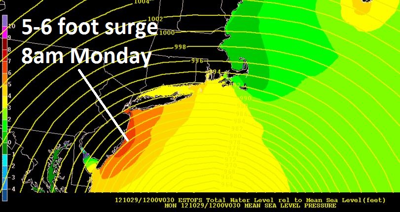
Maximum Storm Surge for New Jersey. According to NOAA "Slosh" models a 5-6 foot surge is most likely to occur during the early morning hours Monday, close to 7-9 am, coinciding with high tide.
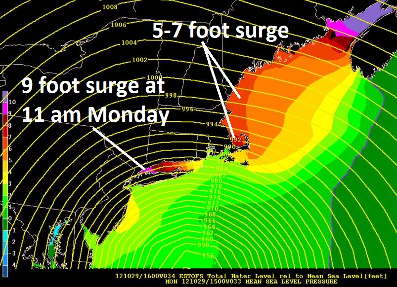
Dangerous Storm Surge #1. NOAA surge models suggest a 9 foot storm surge (above normal sea level) during the late morning hours Monday over far western Long Island Sound, capable of pushing very significant water in Queens and Brooklyn.
Dangerous Storm Surge #2. A second, even higher surge is forecast for the late evening hours Monday, as the center of Sandy comes ashore over central New Jersey -- sustained 60-80 mph winds whipping up a dome of water as much as 10 feet above normal sea level over eastern Long Island, with an 8-9 foot surge for Greenwich, Stamford and Westport.
Sandy Staying On Track. With sustained winds of 75 and gusts to 90, Sandy is evolving from a hurricane into an (extreme) Nor'easter, similar to what happened with Hurricane Grace in 1991. Map: Ham Weather.
Landfall Projection. Alerts Broadcaster weather models calculate hurricane-force winds from Bethany Beach, Delaware northward to Asbury Park at landfall Monday night (red-shaded area). The region impacted by tropical storm-force winds (orange shading) is huge, some 500+ miles wide. Landfall is scheduled for Monday night. Map: Ham Weather.
Convergence. Finally, the models are coming into alignment and nearly universal agreement, showing a probably landfall over New Jersey Monday night. Confidence levels are now (very) high that Sandy won't deviate from this path. Map: Ham Weather.
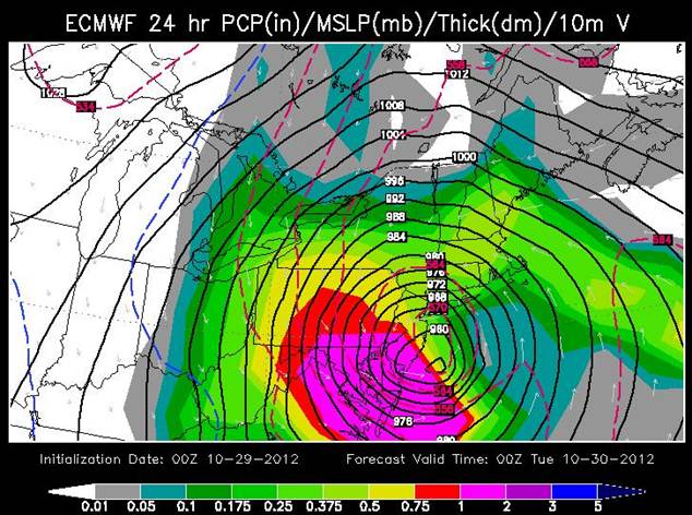
European Solution. The ECMWF was the first to bring "Sandy" into the USA (back on Sunday I was raising this possibility with Alerts Broadcaster customers and prospects), and once again this model is proving to be on the money. The map above is valid 8 pm eastern time Monday evening, showing the center of Sandy approaching Atlantic City, with the most extreme rains from central New Jersey and the Delaware Valley to Baltimore, Annapolis and Washington D.C. Map above: WSI Corporation.
Landfall. The map above shows the expected center of Sandy Monday afternoon at 5 pm, coming ashore near Atlantic City. The strongest winds (map above is for 900 mb, about 1,500 feet above the ground) are from Montauk and coastal Connecticut to coastal Maine. Sustained winds at the surface of 60-80 mph are likely with a few gusts as high as 95 mph. The main concern with the wind: power outages, and creating favorable conditions for a major storm surge. Map: Weather Bell.
Peak Winds. The same 4km NAM model shows peak winds for Boston, The Cape, Providence and Groton during the mid/late afternoon hours -- winds gusts may approach 100 mph. at time as Sandy passes south of Long Island.
Continuity. Most of the models are converging on a track over central New Jersey. Again, the strongest storm surge will come north of Sandy's path tomorrow.
GFS Solution. NHC meteorologists are still putting more stock on the ECMWF and GFS models, which bring extra-tropical Super Storm Sandy into New Jersey. The map above is valid Monday evening around 8 pm, coinciding with high tide and a full moon -- thus the concern for enhanced risk and coastal danger. What is amazing, borderline unprecedented, is the size of this storm, with hurricane-force (74 mph+) wind gusts over a 250 mile wide area, tropical storm force (39 mph+) winds over a 450 mile wide swath on either side of Sandy's west/northwest track.
NOGAPS Solution. The Navy (NOGAPS) computer run (12z) shows a similar solution, slightly closer to metro New York than GFS and NAM. The map above is valid 8 pm eastern time Monday.
GFDL Solution. NHC runs their own high-resolution weather models; the latest run shows landfall near Atlantic City Monday evening around 8pm eastern time; strongest winds from Allentown to New York City and Long Island.
Storm Surge Forecast for Battery Park, Manhattan. Two damaging surges tomorrow, one around 9-11 am, the second between 9 pm and midnight as Sandy tracks inland. Guidance is suggesting a possible 10 foot surge at Battery Park, the most extreme coming Monday night. I expect extensive flooding over lower terrain, mainly Lower Manhattan, as well as Brooklyn, Queens and Staten Island. Map source: NOAA.
King's Point, Long Island. Located just east of La Guardia Airport, the King's Point buoy will see sharp rises in water levels on Long Island Sounds, with a potential for two 11-12 foot storm surges.
Nantucket. A storm surge close to 6 feet above normal sea level is possible at Nantucket, MA around noon tomorrow.
Boston Harbor. NOAA surge data suggests a potential for a 12 foot storm surge in Boston Harbor midday tomorrow. Flooding near Boston and Cape Cod may be nearly as extreme as what we expect to unfold on Long Island Sound, coastal Connecticut and metro New York.
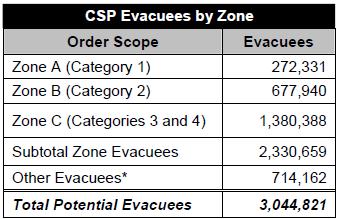
Earlier today Mayor Bloomberg announced mandatory evacuations for Zone A in metro New York, effective by this evening. It's going to be a mad scramble to get 272,000+ people to higher ground and secure shelters by tonight -- I honestly don't know what took them so long to make this decision.
A reminder that all New York City subway, commuter rail and bus transportation will be shut down as of 7 pm eastern time.
Reminder: New York City is divided into 3 Hurricane Evacuation Zones. To determine what zone you're in check the Hurricane Evacuation Zone Finder.
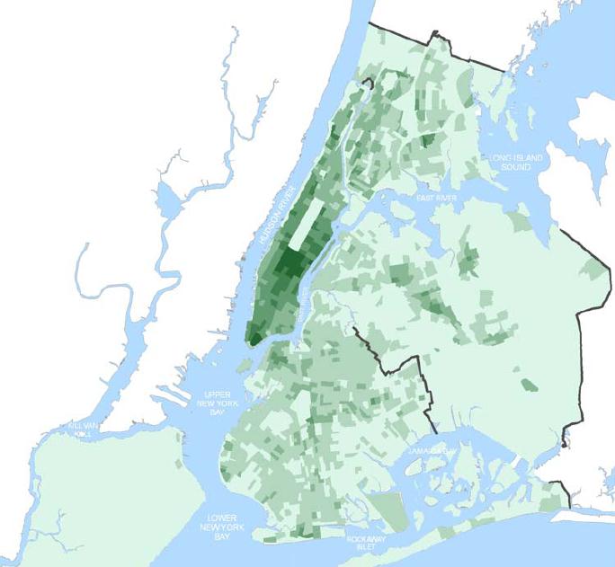
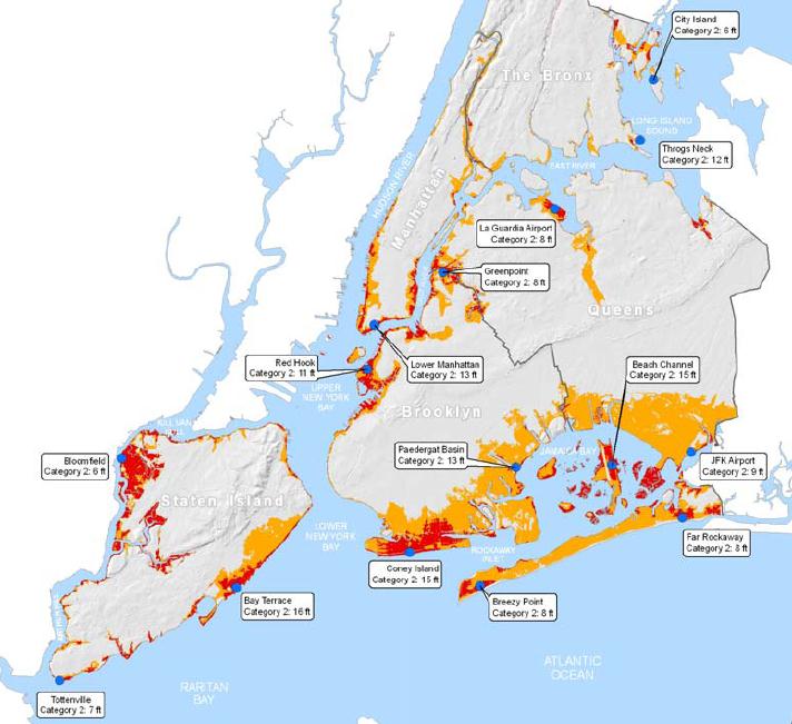
This may be the equivalent of a Category 1+ hurricane for both New York and Boston, factoring in a powerful contrast in air pressure and a storm forecast to be 28.11" just south/east of NYC by Monday evening. Here are the areas of New York that are most prone to flooding in a Category 1-2 storm:

Category 2 Risk Areas. For more information on SLOSH models and the area most prone to lowland flooding click here -- data courtesy of nyc.gov (which I strongly encourage you to scan). Here is an excerpt of a 2009 report:
"A Category 1 hurricane can cause storm surge of up to 10 feet and 95 mile per hour winds causing moderate damage to the City's foliage and unstable buildings along the coast....Density is a major concern for New York City in the context of a hurricane. More than eight million people live within 305 square miles across the five boroughs. New York City's three islands and the main land create 578 miles of coastline. Close to two million people in 743,000 households live within a SLOSH zone and as much as 38% of the City's land may experience inundation by storm surge in a coastal storm...."
Evacuation Potential For New York City. My hunch is that this will be a Category 1+ storm for metro New York, with sustained winds of 60-80 mph, and gusts over 90 mph during the day Monday. Officials will need to move people in high-threat ("Zone A") areas within 1-7 feet of sea level later today. Conditions will rapidly deteriorate late tonight -- Monday still looks like the worst day for wind, waves and storm surge damage, from New York and Providence to Boston.
Alerts Broadcaster Summary: preparations for Sandy should be rushed to completion. Gridlock is likely in New York City by tonight, and coastal highways will begin shutting down overnight as water levels continue to rise. Two potentially damaging storm surges are likely: mid/late morning Monday, with a second surge Monday evening/night as the center of Sandy tracks south of Long Island. Inland flooding is likely, with a high likelihood of power outages as winds gust over 85-90 mph. Monday, bringing down tree limbs. Something as mundane as leaves on the ground may complicate the flood situation, clogging storm drains and storm sewers.
Remember, if you can't get away from sea level (I would suggest coastal residents should try to be at least 10-15 feet above sea level or higher on Monday and Monday night) a vertical evacuation will suffice, reaching the third or fourth story of a well-constructed building, like a hotel, apartment or office building, staying away from outer walls and windows at the height of the storm Monday evening (to avoid injury from debris and possible breaking glass).
Sandy's threat is real. No, the meteorologists are not "hyping the weather". A convergence of factors: huge storm, slow movement, full moon, etc. has created a dangerous situation from the Delmarva Peninsula to Cape Cod and the Boston area, but we suspect the worst flooding will take place from Long Island Sound (impacting coastal Connecticut) to New York Harbor and coastal New Jersey. For the last week we've been sending out these updates, attempting to tell a story, a no-nonsense, hype-free evaluation of the threats posed by this historic storm.
I will continue to send out updates to our valued Alerts Broadcaster clients (and potential prospects and the public via The Huffington Post) as long as the threat to life and property remains, through at least Tuesday morning. Some semblance of normalcy should return to the Northeast by Wednesday, but my sense is that it may take weeks to fully recover from wave, wind and flood damage created by Super Storm Sandy.
This is one storm we'll be telling our grandkids about.
Update -- 01:00pm EST Sunday, 10/28/2012
Moving New Yorkers Out of "Zone A" Is The Right Move. NOAA Slosh models have been consistent, showing a 10 foot rise in water levels, focused in Long Island Sound, Monday afternoon and evening -- at the height of the storm, as Sandy tracks south of Long Island and New York City, the combination of winds and waves allowing water to pile up from coastal New Jersey to the New York Bight/New York Harbor to JFK and LGA (which I expect to be partially under water).
New York officials are getting off to a late start, considering the recent volume of data, suggesting a Monday inundation of low-lying neighborhoods and boroughs -- I suspect the highest storm surge will come Monday afternoon/evening, around the time of the full moon.
MTA Shutting Down New York City Ground Transportation This Evening. Latest from Huffington Post. All subway, commuter rail and bus service shuts down as of 7 pm this evening.
Mandatory Evacuations. More details on Mayor Bloomberg's evacuation order here. New York City is divided into 3 Hurricane Evacuation Zones. To determine if you're in Zone A check the Hurricane Evacuation Zone Finder.
This may be the equivalent of a Category 1+ hurricane from coastal New Jersey to New York City, Long Island and portions of southern New England, factoring in a powerful contrast in air pressure and a storm forecast to be 28.11" just south/east of NYC by Monday evening. Here are the areas of New York that are most prone to flooding in a Category 2 storm:
Category 2 Risk Areas. For more information on SLOSH models and the area most prone to lowland flooding click here -- data courtesy of nyc.gov (which I strongly encourage you to scan). Here is an excerpt of a 2009 report:
"A Category 1 hurricane can cause storm surge of up to 10 feet and 95 mile per hour winds causing moderate damage to the City's foliage and unstable buildings along the coast....Density is a major concern for New York City in the context of a hurricane. More than eight million people live within 305 square miles across the five boroughs. New York City's three islands and the main land create 578 miles of coastline. Close to two million people in 743,000 households live within a SLOSH zone and as much as 38% of the City's land may experience inundation by storm surge in a coastal storm...."

Evacuation Potential For New York City. My hunch is that this will be a Category 1+ storm for New York, with sustained winds of 80-100 mph; officials may need to move people in high-threat areas within 5-8 feet of sea level later today and early Sunday. Conditions will rapidly deteriorate tonight -- Monday looks like the worst day for wind, waves and storm surge damage, from New York and Providence to Cape Cod.

Perspective. No, this won't be a garden-variety Nor'easter.
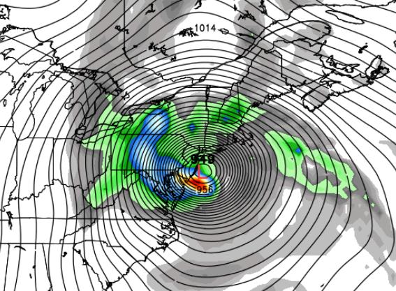
Still On Track. The 06z GFS shows an extreme extra-tropical Nor'easter approaching New York City at 1 pm tomorrow, capable of a very damaging storm surge over Long Island and even pushing into New York Harbor, with hurricane-force winds extending inland as far as Hartford, Albany, Wilkes-Barre and Philadelphia Monday night. The size of tropical storm force winds is unprecedented, probably record-setting. Map: Weather Bell.
No, Sandy Is Not "Shrill Media Hype" It's still coming, if anything the maps look a little more impressive this morning than they did Saturday. Monday is the worst day, with conditions slowly improving Tuesday. If you're not in a secure area by this evening, you may not get out in time -- many coastal roads will become inundated overnight. Map: Ham Weather.
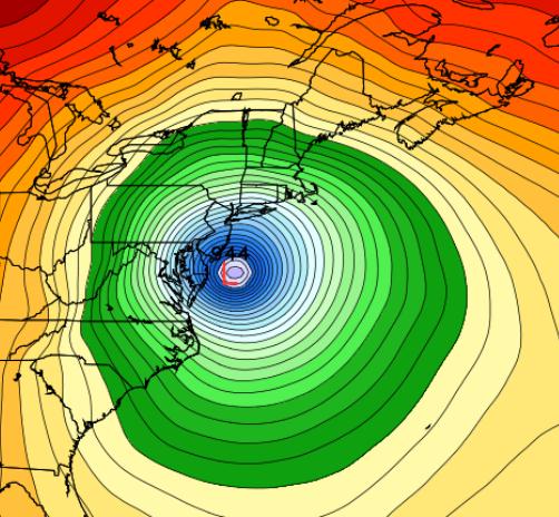
Sandy: Expected To Continue Strengthening. No longer purely a hurricane, deriving energy and strength from warm ocean water, Sandy is already evolving into an (extreme) extra-tropical cyclone; energy from temperature extremes and jet stream winds tightening the circulation, increasing the pressure gradient and deepening the central pressure -- a process which should go on into tomorrow. A blocking high to the north will prevent The Spawn of Sandy from racing out to sea, forcing it to hook inland tomorrow afternoon and night. Image: Naval Research Lab.
Latest Model Ensemble. A majority of weather models bring Sandy's path south of New York City and Long Island Monday evening or early Monday night, near Atlantic City or Asbury Park -- the strongest winds and highest storm surge NORTH of the storm track. Map: Ham Weather.
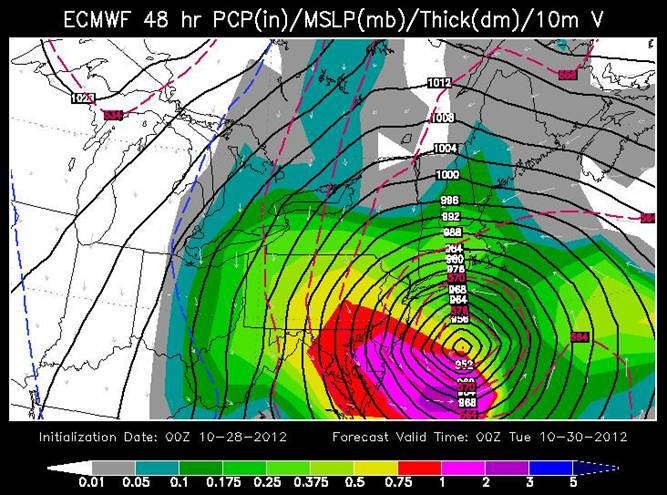
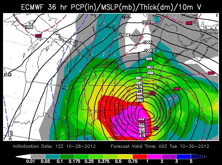
European (ECMWF) Model. The ECMWF was the first model to turn Sandy inland -- back on Monday we predicted that Sandy would, in fact, impact the northeastern USA. So I'm (still) putting a little additional weight on this model, which shows landfall just north of Atlantic City Monday night. Map above valid 7 pm Monday evening; landfall (New Jersey) likely 3-4 hours later. The purple-shaded area designates the most extreme rains, with as much as 1-2" of rain falling every 3 hours from the Delaware Valley into south Jersey. The greatest impact of inland flooding comes Monday afternoon into Tuesday morning. Map: WSI Corporation.
GFS Model. Underscoring and validating the ECMWF simulation, the latest GFS run also shows a landfall near Atlantic City Monday evening at 7 pm (06z GFS run). The map above is valid 1 pm Monday, showing Sandy approaching coastal New Jersey, pushing a massive surge of water into Cape Cod, Providence, Long Island and New York Harbor. This could still evolve into to a worst-case scenario for some of New York's boroughs; sustained east/southeast winds, coupled with extremely low pressure, carving out a dome of water, a "storm surge", as much as 5-10 feet above normal high tide. A full moon Monday increases the risk of historic flooding, possibly comparable to the June 22, 1972 flood, which was sparked by Tropical Storm Agnes fusing with another storm, resulting in 122 deaths and $6 billion in damage (nyc.gov).
Canadian Model Solution. The GEMS model from Environment Canada is consistent with NOGAPS, GFS and ECMWF guidance, along with the NAM and GFDL, "hooking" Sandy inland Monday evening and early Monday night, nearly a 500 mile wide fan of tropical storm to near hurricane-force winds, which I don't think I've ever seen before. I want to stress that Boston, Cape Cod, Martha's Vineyard, Nantucket, Providence and coastal Long Island will also experience potentially historic flooding, due to the combination of a powerful differential in air pressure, slow movement and a full moon late Monday.
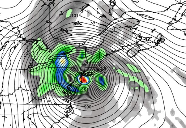
Sprawling Wind Field. This is a map showing the huge swath of hurricane-force winds at 4 pm Monday, stretching from near Boston and Cape Cod to coastal Rhode Island, Connecticut and Long Island. These are wind predictions for 900 mb, about 1,500 feet above the ground, showing 100+ mph winds over southern New England. I expect surface winds to be in the 70-95 mph range from midday Monday into early Tuesday morning. Weather Underground reports Sandy is already the second largest system on record since 1988, based on the size of the wind field. Data: NAM-WRF.

Dangerous Storm Surge. NOAA's "Slosh" models are showing a storm surge as high as 6-10 feet above mean sea level Monday evening at 10 pm over the westernmost tip of Long Island Sound -- pushing water into Queens and Brooklyn. Both JFK and LGA may see runways inundated by rapidly rising water as Sandy tracks just south of Long Island. Again, maybe I'm missing something here -- but I can't understand why people aren't being evacuated, at least in the most high-risk areas within 6 feet from seas level. I don't get it. Map above: NOAA.
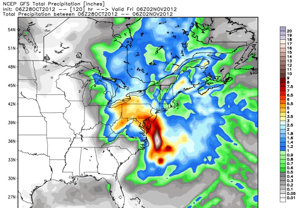
Remembering Irene: Don't Underestimate Risk of Inland Flooding. NOAA HPC is predicting a wide swatch of 4-8" rains from Sandy, the greatest potential for inland flooding from the Delmarva Peninsula and south Jersey inland to Philadelphia, Lancaster, York, Baltimore and Washington D.C. -- based on the latest GFS guidance.
Monday Storm Surge. NOAA models are hinting at a 5 foot storm surge Monday evening along the Jersey shore -- map above valid 7 pm Monday.

What Will Keep Me Up Tonight? At the risk of being repetitive, we're not pulling these maps out of thin air -- NOAA's "Slosh" model is hinting at a 6-10 foot storm surge for Long Island Sound by 7-10 pm Monday; the combination of sustained 60-80 mph. winds and low pressure (and a full moon) carving out a "dome" of water, pushed along by Sandy -- water literally piling up north of Long Island -- pushing toward LGA, JFK and lowland areas of Brooklyn and Queens. Vulnerable people need to be moved -- evacuated out of harm's way, especially nursing homes and hospitals; where people won't be able to move under their own power tomorrow.
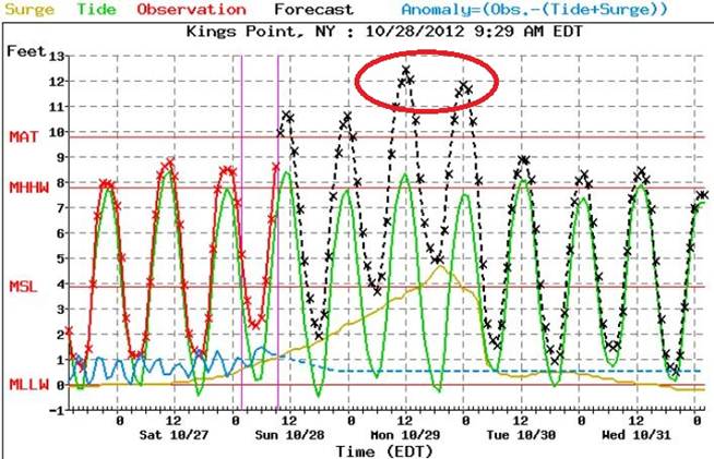
8-12 Foot Storm Surge? Here is the NOAA forecast for Kings Point, New York, east of La Guardia Airport, showing a steady rise in water levels, peaking Monday midday at high tide -- the combination of storm surge, high tide (and full moon) creating a possible 10+ rise in water levels in Long Island Sound. I suspect runways at LGA and JFK may be under a fair amount of salt water.
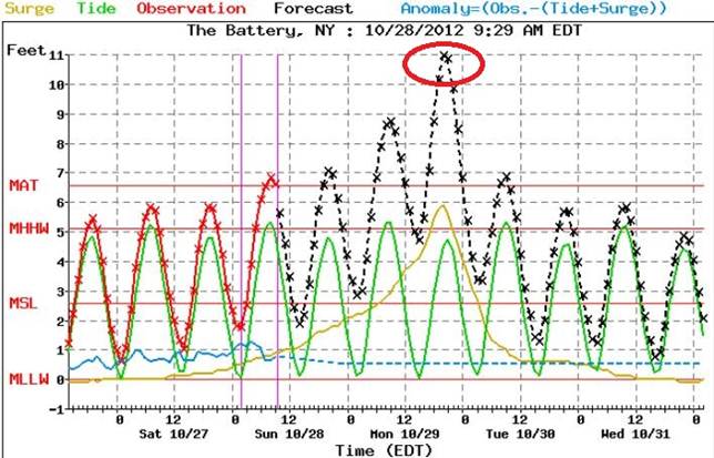
Major Flooding For Lower Manhattan? Here is the NOAA forecast for water levels at The Battery -- showing some potentially jaw-dropping rises in water levels. A storm surge of 4-5 feet, superimposed high tide (and full moon) may have some very unpleasant consequences for low-lying areas of Manhattan, Brooklyn, Queens and Staten Island.
Hurricane Preparation. Details from FEMA's ready.gov website:
- To begin preparing, you should build an emergency kit and make a family communications plan.
- Know your surroundings.
- Learn the elevation level of your property and whether the land is flood-prone. This will help you know how your property will be affected when storm surge or tidal flooding are forecasted.
- Identify levees and dams in your area and determine whether they pose a hazard to you.
- Learn community hurricane evacuation routes and how to find higher ground. Determine where you would go and how you would get there if you needed to evacuate.
- Make plans to secure your property:
- Cover all of your home's windows. Permanent storm shutters offer the best protection for windows. A second option is to board up windows with 5/8" marine plywood, cut to fit and ready to install. Tape does not prevent windows from breaking.
- Install straps or additional clips to securely fasten your roof to the frame structure. This will reduce roof damage.
- Be sure trees and shrubs around your home are well trimmed so they are more wind resistant.
- Clear loose and clogged rain gutters and downspouts.
- Reinforce your garage doors; if wind enters a garage it can cause dangerous and expensive structural damage.
- Plan to bring in all outdoor furniture, decorations, garbage cans and anything else that is not tied down.
- Determine how and where to secure your boat.
- Install a generator for emergencies.
- If in a high-rise building, be prepared to take shelter on or below the 10th floor.
- Consider building a safe room.
Why No Hurricane Watches or Warnings? Because Sandy is transitioning from a warm-core (ocean-powered) hurricane into an extra-tropical low pressure system, a classic Nor'easter, fed by powerful temperature extremes and swirling jet stream winds aloft to amplify and focus the storm's fury. More details on the transition and terminology from NHC, via Facebook:
"...thus, once Sandy loses its tropical cyclone status it will be know as "Post-tropical Cyclone Sandy" in NWS products. Some aspects of this transition are already occurring, and NWS forecasts of storm impacts are based on this expected evolution. Regardless of when this transition occurs, Sandy is expected to bring significant wind, surge, rainfall and inland flooding hazards over an extremely large area, and snowfall to more limited areas. Because Sandy is expected to make this transition before reaching the coast, the NWS has been using non-tropical wind watches and warnings, issued by local NWS Weather Forecast Offices (WFO's), to communicate the wind threat posed by Sandy in the Mid-Atlantic States and New England (this is why NHC's tropical storm warnings extend only into North Carolina). The NWS plans to continue using non-tropical watches and warnings issued by local offices in the Mid-Atlantic States and northward throughout this event. By using non-tropical warnings in these areas from the start, we avoid or minimize the significant confusion that could occur if the warning suite changed from tropical to non-tropical in the middle of the event."
NOAA HFIP -- Experimental Real-Time High Resolution Forecasts. Forecast track courtesy of NOAA AOML.
New York City's Most Destructive Storms Since 1821. File photo credit here.
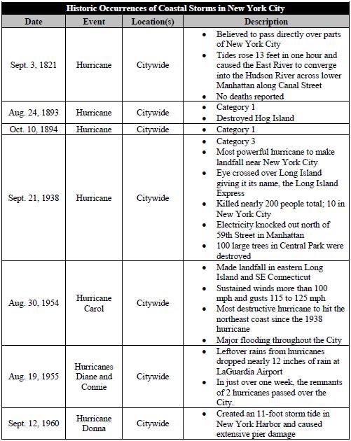
Perspective. If a storm surge forecast of 5-10 feet verifies in the New York City area it would be the worst flooding since Gloria in 1985, possibly since ex-Tropical Storm Agnes merged with an extra-tropical low pressure system to produce massive flooding in late June, 1972. Source: nyc.gov.
National Weather Service: "A Storm Like No Other". Details (and video) from The Associated Press: "The National Weather Service says Hurricane Sandy is an extremely unique storm that will hit the U.S. with strong winds and rain, potentially causing massive damage."
Summary: Little has changed -- the threat is real. This storm will be historic. I understand cynicism and skepticism when it comes to meteorology. We've all be burned by multiple storms, and there is a tendency to discount what the weather community is saying. The National Weather Service (NOAA) called this "A Storm Like No Other." I couldn't agree more.
At this point I wouldn't wait for local authorities to make the (evacuation) call, because I'm becoming more and more convinced they may not make the (right) call until it's too late to safely move a significant number of people.
Safeguard your property as best you can -- but now it's about protecting people and lowering the risk of death and injury, primarily due to rapidly rising seas tomorrow -- as multiple storm surges are pushed ashore by Sandy's battering-ram winds, coupled with the (very) unfortunate timing of a full moon.
If you live within 6-10 feet of sea level -- in any of New York's boroughs, coastal Long Island, Connecticut or New Jersey -- it's time to initiate an Action Plan that takes you away from the high-threat areas. Execute your emergency plans and err on the side of caution. Conditions should slowly improve Tuesday as the soggy remains of Soggy push toward State College, PA, slowly weakening. Water levels (from coastal storm surge flooding and inland flooding) should slowly recede Tuesday with some sense of normalcy returning by Wednesday.
I've walked you through 6 days of weather models converging on pretty much a worst-case scenario for metro New York, and Sandy isn't taking her foot off the gas.
Another update this afternoon. Good luck -- stay safe.
Update -- 06:40pm EST Saturday, 10/27/2012
Alerts Broadcaster Update: Hurricane Sandy is still on track to become a record storm for much of the Mid-Atlantic and Northeast; as many as 50-75 million Americans may be impacted by high winds, coastal flooding and extensive inland flooding by Tuesday. A few headlines:
* Conditions deteriorate during the day Sunday, from south to north across the Mid-Atlantic region. Accelerate preparations to secure facilities and safeguard staff early in the day Sunday.
* The storm peaks Monday and Monday night; conditions slowly improve by Tuesday afternoon as the center of Sandy moves inland and slowly dissipates.
* New York City officials are discussing evacuation plans and even closing the subways at the height of the storm (Monday). "SLOSH" simulations are predicting as much as 6-9 feet of water pushing across Long Island Sound into parts of Queens and Brooklyn. A storm surge coming up New York Harbor may flood Lower Manhattan and Battery Park. Areas within 5 feet of sea level are threatened. My hunch: La Guardia Airport and JFK may see runway inundation Monday, with as much as 1-3 feet of standing water on some runways.
* NBC in New York reports that MTA officials are considering shutting down subways, bridges and commuter rails by 7 pm Sunday. No final decision has been made as of 5 pm eastern time, but I anticipate that this will, in fact, happen. Don't wait until the last minute.
* A 4-8 foot storm surge is possible over coastal New Jersey and the southern coastline of Long Island. Communities that have a history of severe flooding during hurricanes and severe Nor'easters can expect widespread flooding from Sandy.
* Many coastal highways within 3-4 feet of sea level will be closed by Sunday night. Again, if you plan to evacuate away from the coast/sea level, the time to do it is now, or Sunday morning at the latest.
Minimal Hurricane -- Maximum Punch. Don't be fooled by Sandy's Category 1 ranking. A powerful contrast in pressure between this deepening storm, and a blocking ridge of high pressure to the north, will create a vast area of 50-90 mph winds late Sunday into Tuesday morning, as much as 250 miles wide as the storm "hooks" westward, probably passing just south of Long Island and New York City. Map: Ham Weather.
Latest Model Ensemble. A majority of weather models bring Sandy's path south of New York City and Long Island. Keep in mind that the most extreme storm surge will take place north of wherever Sandy comes ashore. We are placing special emphasis (as is NHC) on the GFS and ECMWF (European) solutions. Map: Ham Weather.
European (ECMWF) Model. The ECMWF was the first model to turn Sandy inland -- back on Monday we predicted that Sandy would, in fact, impact the northeastern USA. So I'm putting a little additional weight on this model, which shows landfall just north of Atlantic City Monday night. Map above valid 1 am Tuesday morning. The purple-shaded area designates the most extreme rains, with as much as 1-2" of rain falling every 3 hours from the Delaware Valley to Washington D.C. The greatest impact of inland flooding comes Monday afternoon into Tuesday morning. Map: WSI Corporation.
GFS Model. Underscoring and validating the ECMWF simulation, the latest GFS run also shows a landfall near Atlantic City Monday evening. A worst-case scenario for Manhattan: sustained southeast winds, coupled with extremely low pressure, carving out a dome of water, a "storm surge", as much as 5-10 feet above normal high tide. A full moon Monday increases the risk of historic flooding, possibly comparable to the June 22, 1972 flood, which was sparked by Tropical Storm Agnes fusing with another storm, resulting in 122 deaths and $6 billion in damage (nyc.gov).
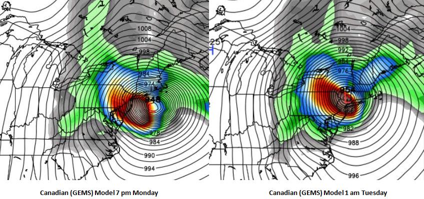
Canadian Model Solution. The GEMS model from Environment Canada shows a vaguely similar left-hand turn for Sandy late Monday into Tuesday morning, with the core of the storm passing almost directly over New York City by 1 am Tuesday morning. I want to stress that Boston, Cape Cod, Martha's Vineyard, Nantucket, Providence and coastal Long Island will also experience potentially historic flooding, due to the combination of a powerful differential in air pressure, slow movement and a full moon late Monday. Map: Weather Bell.
Sprawling Wind Field. This is a map showing the huge swath of hurricane-force winds at 1 pm Monday, stretching from near Boston and Cape Cod to coastal Rhode Island, Connecticut and Long Island. These are wind predictions for 900 mb, about 1,500 feet above the ground, but I expect surface winds to be in the 70-95 mph range from midday Monday into early Tuesday morning. Data: NAM-WRF.
Dangerous Storm Surge. NOAA's "Slosh" models are showing a storm surge as high as 9 feet above mean sea level Monday evening at 7 pm over the westernmost tip of Long Island Sound -- pushing water into Queens and Brookyn. Both JFK and LGA may see runways inundated by rapidly rising water as Sandy tracks just south of Long Island. Map above: NOAA.
Summary: Sandy is still on track to deliver a punishing blow to much of the northeast, the slow speed, extreme pressure gradient and full moon on Monday making this historic Nor'easter equivalent to a Category 1-2 hurricane. It's still impossible to pin down where the most severe storm surge will take place -- the level of water hinges on the precise track Sandy takes as it passes south of Long Island and New York City Monday.
Consider accelerating your preparations to safeguard life and property. Remember the impact of inland flooding -- many towns will lose power for several days, perhaps longer. If you live within 5-7 feet of sea level, in an arc from New Jersey to New York to Long Island and southern New England, have a Plan B, well inland. The best advice if you can't reach higher ground in time: vertical evacuations. Find shelter on the third or fourth floor of a well constructed building (office complex or hotel), well away from outer walls and windows to safeguard yourself from flying debris and broken glass.
Sandy may be a hybrid hurricane -- Nor'easter by the time it pushes ashore Monday night; but there's little doubt this will be an historic storm.
Another update Sunday morning. Good luck -- stay safe.
Update -- 09:30am EST 10/27/2012
Threat Increases for New Jersey, Metro New York, Long Island, Boston and coastal New England.
Alerts Broadcaster Update: Don't be misled into thinking the threat has eased because "Sandy" is a tropical storm. All the models show a rapidly re-intensifying storm tonight and Sunday as an approaching surge of Canadian air energizes the system; a dramatic contrast in barometric pressure producing hurricane-force winds into Monday over a broad, 200-250 mile wide arc approaching coastal Delaware, New Jersey and far southern New England. Sandy is still a force to be reckoned with, still a potentially historic storm from Cape May and Atlantic City northward to New York City and bedroom communities of coastal Long Island.
Latest models are strongly suggesting a heightened risk for New York City, Long Island, Providence, Cape Cod and the islands (Nantucket and Martha's Vineyard). The northward wobble I talked about earlier today continues, and there is now a 70-75% risk that Sandy will pass just south of New York City Monday morning.
The worst-case scenario for New York is a track just south of the city, with sustained hurricane-force southeast winds, capable of funneling water into New York Harbor and right up the Hudson and East Rivers. That scenario now looks considerably more likely than it did 12-24 hours ago. A more northward track also increases the threat for Cape Cod, the islands (Nantucket and Martha's Vineyard) and even metro Boston, which will see a strong, sustained fetch of 60-90 mph winds Monday.
Model Ensemble. Sandy will lose some of its hurricane characteristics over the next 48 hours, transitioning from a warm-core storm (one that gets energy from warm ocean water) to an extra-tropical low that derives energy from large temperature contrasts and high-velocity jet stream winds funneling into the system, spinning up a meteorological monster of a low pressure system, what meteorologists call a "bomb". Landfall solutions range from Ocean City, Maryland to Nantucket, but most solutions are centering on Monday landfall over New Jersey. Map: Ham Weather.
ECMWF Monday Evening. The models aren't backing down, still suggesting a Super-Storm with a central pressure of 28.10" to 28.15" of mercury by Monday afternoon approaching coastal New Jersey. The most intense winds, waves and resulting storm surge will be north of where the center of Sandy comes ashore, within 100-200 miles of landfall, which puts metro New York into the high-risk zone from storm surge inundation -- but hurricane force gusts are possible as far away from the center as metro Boston. Map: Weather Bell.
GFS Model. Most of the models are converging on a solution close to the GFS (above), valid Monday evening at 7pm, showing the center of Sandy (hybrid hurricane/Nor'easter) coming ashore between Cape May, New Jersey and New York City. The worst coastal flooding and storm surge will extend 100-150 miles north of where the center of the storm comes ashore. If Sandy tracks (just) south of NYC flooding in Lower Manhattan and other boroughs within 5-10 feet of sea level may experience major lowland flooding as well.
NOGAPS Model. The Navy model is in line with GFS, showing Sandy "hooking" inland, on a track south of Long Island and Cape Cod. This would sustain high winds and surf into south-facing communities for an extended period of time. Monday still looks like the worst day.
Models Converging on a Final Solution. As landfall approaches the weather models should begin to align (in theory), and that is, in fact, happening -- although not as fast as we'd like to see. The Canadian (GEMS) model above is valid 1 pm Monday, showing a track south of Long Island and New York City.
Monday, 1 pm Winds 1,000 Feet Aloft. The NAM-WRF model shows hurricane-force winds possible from New York City to Boston during the day Monday.
Inland Flooding Potential. The 4 km. WRF-NAM model shows some 5-8" rains from the Outer Banks and Tidewater of Virginia northward to Washington D.C. and Bethany Beach, Delaware by Monday morning. Expect widespread flash flooding, capable of leaving many roads impassable.
Again, I'm struck by the sheer size of this storm, with hurricane force winds impacting an area 200-250 miles wide. Expect widespread power outages that may last several days, possibly over a week or two in some localities, with serious inland flooding. Many roads, especially near sea-level, will be inundated.
My suggestion: consider moving people today, while conditions are still passable. There is now sufficient evidence that this will be an historic storm for New York City, Long Island, and much of southern New England, and I would strongly advise erring on the side of extreme caution and protecting life and property.
New York City is divided into three Hurricane Evacuation Zones. To determine what zone you're in check the Hurricane Evacuation Zone Finder.
This may be the equivalent of a Category 1+ hurricane for both New York and Boston, factoring in a powerful contrast in air pressure and a storm forecast to be 28.11" just south/east of NYC by Monday evening. Here are the areas of New York that are most prone to flooding in a Category 2 storm:

Category 2 Risk Areas. For more information on SLOSH models and the area most prone to lowland flooding click here -- data courtesy of nyc.gov (which I strongly encourage you to scan). Here is an excerpt of a 2009 report:
"A Category 1 hurricane can cause storm surge of up to 10 feet and 95 mile per hour winds causing moderate damage to the City's foliage and unstable buildings along the coast....Density is a major concern for New York City in the context of a hurricane. More than eight million people live within 305 square miles across the five boroughs. New York City's three islands and the main land create 578 miles of coastline. Close to two million people in 743,000 households live within a SLOSH zone and as much as 38% of the City's land may experience inundation by storm surge in a coastal storm...."

Evacuation Potential For New York City. My hunch is that this will be a Category 1+ storm for New York, with sustained winds of 80-100 mph; officials may need to move people in high-threat areas within 5-8 feet of sea level later today and early Sunday. Conditions will rapidly deteriorate Sunday night -- Monday looks like the worst day for wind, waves and storm surge damage, from New York and Providence to Boston.
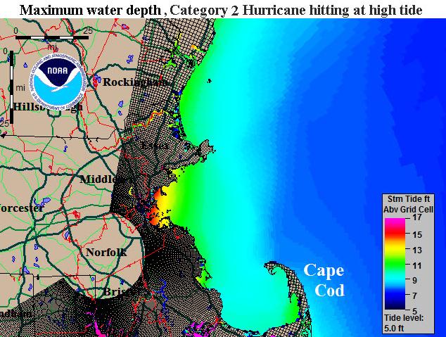
Category 2 Equivalent Storm Impact on Boston. This graphic (NOAA) shows the extent of coastal flooding from a hurricane (or extreme Nor'easter) hitting Boston at high tide, a potential for 13-15 foot surge into Boston Harbor. We'