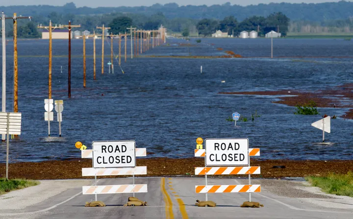
HAMBURG, Iowa (AP) -- Water that has been pouring through a breached Missouri River levee finally reached a makeshift barrier that is a small Iowa town's only hope of avoiding major flooding, authorities said Thursday.
The water, which breached the primary levee south of Hamburg on Monday and has been slowly advancing over the surrounding farmland, reached the 8-foot-tall levee late Wednesday and was about 2-feet-deep by Thursday morning, Army Corps of Engineers spokesman Carlos Lazo said. There were no immediate problems reported along the structure, where officials expect about five feet of water to eventually collect.
Crews finished work on the 3-mile-long levee on Wednesday by covering it with plastic to reduce erosion. And most of those living in the threatened parts of town have cleared out.
Any hopes that the breaches might alleviate the long-term flooding threat for communities downstream were short-lived, as river levels that dipped slightly from the release of pressure began their re-ascent Wednesday.
The river has been rising for weeks as the corps releases increasing amounts of water from its upstream dams to clear out heavy spring rain and snowmelt. Releases at Gavins Point Dam in South Dakota hit the maximum planned amount of 150,000 cubic feet of water per second Tuesday, and the corps wasn't planning to reduce the amount it's releasing from its dams until August at the earliest.
Parts of Montana, North Dakota and South Dakota already have been flooded, and towns and cities farther south were still bracing for the worst. South Dakota officials estimate the state already has spent about $10 million in the first two weeks of work to prevent flooding in Pierre, Fort Pierre and Dakota Dunes.
River towns and cities in Nebraska, Iowa and Missouri continued bolstering their own flood defenses Wednesday, probing for any potential weakness.
"If there are weak spots, they will be shown very soon," National Weather Service hydrologist Dave Pearson said.
Officials predict the river downstream of the six dams will remain 5 to 7 feet above flood stage at most places in Nebraska and Iowa, and swell as much as 10 feet above flood stage in Missouri.
Pearson said Monday's breaches would provide only a temporary dip in river levels. Once the water spreads out, the pressure will build up and the river will rise again.
"The water is continually being replenished, so it's going to go back up again," Pearson said.
That was already the case near Brownville, Neb., just downstream of the breaches, where the river level fell from 40.74 feet on Monday to 39.54 feet on Tuesday. The river had started rising again by 3 p.m. Wednesday, when it was at 39.92 feet.
John LaRandeau, a civil engineer with the corps, said the situation along the Missouri River is distinctly different than the one along the Mississippi River earlier this spring, when the corps intentionally breached a levee south of Cairo, Ill., to reduce the risk of flooding in that city. In that case, the Mississippi water levels were expected to recede soon after the breach, whereas the Missouri levels are not.
"The pressure on the levees is going to be very, very high," he said.
Funk reported from Omaha, Neb. Associated Press writers Timberly Ross in Omaha and Chet Brokaw in Pierre, S.D. contributed to this report.
National Weather Service river forecast: http://water.weather.gov/ahps2/index.php?wfooax
U.S. Army Corps of Engineers Omaha District: http://www.nwo.usace.army.mil
U.S. Army Corps of Engineers Kansas City District: http://www.nwk.usace.army.mil
Our 2024 Coverage Needs You
It's Another Trump-Biden Showdown — And We Need Your Help
The Future Of Democracy Is At Stake
Our 2024 Coverage Needs You
Your Loyalty Means The World To Us
As Americans head to the polls in 2024, the very future of our country is at stake. At HuffPost, we believe that a free press is critical to creating well-informed voters. That's why our journalism is free for everyone, even though other newsrooms retreat behind expensive paywalls.
Our journalists will continue to cover the twists and turns during this historic presidential election. With your help, we'll bring you hard-hitting investigations, well-researched analysis and timely takes you can't find elsewhere. Reporting in this current political climate is a responsibility we do not take lightly, and we thank you for your support.
Contribute as little as $2 to keep our news free for all.
Can't afford to donate? Support HuffPost by creating a free account and log in while you read.
The 2024 election is heating up, and women's rights, health care, voting rights, and the very future of democracy are all at stake. Donald Trump will face Joe Biden in the most consequential vote of our time. And HuffPost will be there, covering every twist and turn. America's future hangs in the balance. Would you consider contributing to support our journalism and keep it free for all during this critical season?
HuffPost believes news should be accessible to everyone, regardless of their ability to pay for it. We rely on readers like you to help fund our work. Any contribution you can make — even as little as $2 — goes directly toward supporting the impactful journalism that we will continue to produce this year. Thank you for being part of our story.
Can't afford to donate? Support HuffPost by creating a free account and log in while you read.
It's official: Donald Trump will face Joe Biden this fall in the presidential election. As we face the most consequential presidential election of our time, HuffPost is committed to bringing you up-to-date, accurate news about the 2024 race. While other outlets have retreated behind paywalls, you can trust our news will stay free.
But we can't do it without your help. Reader funding is one of the key ways we support our newsroom. Would you consider making a donation to help fund our news during this critical time? Your contributions are vital to supporting a free press.
Contribute as little as $2 to keep our journalism free and accessible to all.
Can't afford to donate? Support HuffPost by creating a free account and log in while you read.
As Americans head to the polls in 2024, the very future of our country is at stake. At HuffPost, we believe that a free press is critical to creating well-informed voters. That's why our journalism is free for everyone, even though other newsrooms retreat behind expensive paywalls.
Our journalists will continue to cover the twists and turns during this historic presidential election. With your help, we'll bring you hard-hitting investigations, well-researched analysis and timely takes you can't find elsewhere. Reporting in this current political climate is a responsibility we do not take lightly, and we thank you for your support.
Contribute as little as $2 to keep our news free for all.
Can't afford to donate? Support HuffPost by creating a free account and log in while you read.
Dear HuffPost Reader
Thank you for your past contribution to HuffPost. We are sincerely grateful for readers like you who help us ensure that we can keep our journalism free for everyone.
The stakes are high this year, and our 2024 coverage could use continued support. Would you consider becoming a regular HuffPost contributor?
Dear HuffPost Reader
Thank you for your past contribution to HuffPost. We are sincerely grateful for readers like you who help us ensure that we can keep our journalism free for everyone.
The stakes are high this year, and our 2024 coverage could use continued support. If circumstances have changed since you last contributed, we hope you'll consider contributing to HuffPost once more.
Already contributed? Log in to hide these messages.