Google has crushed the hopes of Atlantis hunters everywhere by removing from Google Earth an image that had been rumored to be of the lost city.
The image, which was discovered in 2009, was especially compelling for Atlantiophiles, because it was located in one of the areas where the ancient city was thought to have been built, reports The Daily Mail.
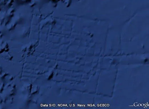
Although the web behemoth kept the image up for three years, it has maintained since the beginning that the pattern was caused by an error in shipboard sounding data and not by an ancient city that disappeared into the ocean. Two oceanography experts who wrote a post for Google's official blog pointed out that if the grid did in fact depict Atlantis, some of the city blocks would have been eight miles long.
The change -- and disappearance of "Atlantis" -- is part of joint effort by Google, Scripps Institute of Oceanography, the National Oceanic and Atmospheric Administration (NOAA), the U.S. Navy and others to improve the quality of Google Earth's underwater imaging.
According to a quote from Scripps geophysicist David Sandwell, which was posted on the Scripps website, part of the work was done by college students. Sandwell stated, "UCSD undergraduate students spent the past three years identifying and correcting the blunders as well as adding all the multibeam echosounder data archived at the National Geophysical Data Center in Boulder, Colorado."
The update, announced on Google's blog, was timed to coincide with the three-year anniversary of the launch of Google Earth's 3D ocean. The major goal of the update was clean up mistakes in the oceanic topography images and make them more accurate. According to the Google Lat Long Blog, after the changes, 15 percent of the ocean floor (up from 10 percent) is now visible at a resolution of 1km. Google Earth's oceanic maps now match those used by researchers, which makes them much more useful as a scientific tool. (Read more about the changes here)
The new data was collected by American and European satellites as well as shipboard sounding surveys from over 40 countries. According to a video posted on YouTube, the five locations of major improvement include the Rosemary Bank seamount off the west coast of Ireland; an area south of Cypress, where the Eurasian and Arabian plates meet; the Britannia and Brisbane table mounts south of the Great Barrier Reef, the Marianas Trench near the island of Guam, and of course the place off the coast of Morocco called the Madeira Abyssal Plane where "Atlantis" was found. See what the "Atlantis" location actually looks like here.
According to Global Adventures, LLC, the next major upgrade to Google Earth, which launched in 2005, is expected to have twice the accuracy of the current maps and will likely happen sometime this year.
Fake Atlantis isn't the only strange image recorded on Google earth; read our article on the 36 weirdest Earth images, or take a look at the slideshow below. Google Maps finds some pretty weird things too. Check out horse boy, alien boy and the three-legged man in our slideshow of craziest Google Street View images.
Loading Slideshow
'Atlantis' Underwater City, Atlantic Ocean
<a href="http://www.huffingtonpost.com/social/Jenius"></a><a href="http://www.huffingtonpost.com/social/Jenius">Jenius</a>:<br />
Italy's Big Pink Bunny
View it at <a href="http://maps.google.com/?ie=UTF8&t=k&om=1&ll=44.244273,7.769737&spn=0.002206,0.004227" target="_hplink">Google Maps</a>. (Via <a href="http://www.pcworld.com/article/134186/in_pictures_the_strangest_sights_in_google_earth.html" target="_hplink">PCWorld</a>)
Mystery Figure
Via <a href="http://www.youtube.com/watch?v=Wr0qiivJZgI&feature=player_embedded" target="_hplink">YouTube</a>.
Blue Tree, Australia
View it at <a href="http://googlesightseeing.com/maps?p=2005&c=&t=k&hl=en&ll=-34.073198,150.75777&z=19" target="_hplink">Google Sightseeing</a>.
Bottomless Pit, Libya
Via <a href="http://www.techeblog.com/elephant/photo.phtml?post_key=160547&photo_key=35314" target="_hplink">TechEBlog</a>.
Iraq's Mysterious Red Lake
View it at <a href="http://maps.google.com/maps?f=q&source=s_q&hl=en&geocode=&q=33+23%2746.08%22+N+44+29%2717.03%22E&sll=33.550551,-44.483643&sspn=4.046476,9.799805&ie=UTF8&ll=33.396999,44.488063&spn=0.007918,0.01914&t=h&z=16&iwloc=addr" target="_hplink">Google Maps</a>. (Via <a href="http://www.time.com/time/specials/packages/article/0,28804,1881770_1881787_1881782,00.html" target="_hplink"><i>TIME</i></a>)
Comet
Via <a href="http://www.techeblog.com/elephant/photo.phtml?post_key=160547&photo_key=35336" target="_hplink">TechEBlog</a>.
'UFO'
Via <a href="http://www.techeblog.com/elephant/photo.phtml?post_key=160547&photo_key=35315" target="_hplink">TechEBlog</a>.
'The Badlands Guardian,' Alberta, Canada
View it at <a href="http://maps.google.com/maps?f=q&source=s_q&hl=en&geocode=&q=50+00%2737.76%22+N+110+07%2700.86%22W&sll=33.225406,-111.595216&sspn=0.003967,0.00957&ie=UTF8&ll=50.010952,-110.11513&spn=0.006095,0.01914&t=h&z=16" target="_hplink">Google Maps</a>. (Via <a href="http://www.canada.com/globaltv/edmonton/story.html?id=977b4fcb-81ad-4c44-bbfa-baaa800c6dc5&k=30095." target="_hplink">canada.com</a>)
The Firefox, Oregon
View it at <a href="http://maps.google.com/?ie=UTF8&om=1&z=16&ll=45.123785,-123.113962&spn=0.012112,0.024097&t=h" target="_hplink">Google Maps</a>.
KFC Mapversiting, Nevada
Read more about this advertising strategy <a href="http://www.foxnews.com/story/0,2933,229308,00.html" target="_hplink">here</a>. View the real thing at <a href="http://maps.google.com/maps?ll=37.646,-115.7507&spn=0.01,0.01&t=p&q=37.646,-115.7507" target="_hplink">Google Maps</a>.
Capsized Boat, Iraq
View it at <a href="http://maps.google.com/maps?ll=30.541634,47.825445&z=16&hl=en&t=h" target="_hplink">Google Maps</a>.
Triple Rainbow, South Carolina
Via <a href="http://www.rodsbot.com/google-earth-3665.htm" target="_hplink">RodsBot.com</a>.
Desert 'Crop Circle,' Nevada
View it at <a href="http://maps.google.com/maps?ll=37.401437,-116.86773&z=15&hl=en&t=h" target="_hplink">Google Maps</a>. (Via <a href="http://www.pcworld.com/article/134186/in_pictures_the_strangest_sights_in_google_earth.html" target="_hplink">PCWorld</a>)
'Eat Pecans,' New Mexico
View it at <a href="http://googlesightseeing.com/maps?p=585&c=&ll=32.241354,-106.707501&spn=0.006405,0.009673&t=k&z=0&hl=en" target="_hplink">Google Sightseeing</a>.
Crop Circle
Via <a href="http://www.techeblog.com/elephant/photo.phtml?post_key=160547&photo_key=35292" target="_hplink">TechEBlog</a>.
Truck Accident, North Dakota
Via <a href="http://googlesightseeing.com/2007/03/truck-crash/" target="_hplink">Google Sightseeing</a>.
Expletive
Via <em><a href="http://www.theregister.co.uk/2006/02/10/giant-profanity/" target="_hplink">The Register</a></em>.
Concentric Shapes
Via <a href="http://www.youtube.com/watch?v=Wr0qiivJZgI&feature=player_embedded" target="_hplink">YouTube</a>.
Pac Man
Via <a href="http://www.gearthblog.com/blog/archives/2006/11/crop_circles_in_goog.html" target="_hplink">Google Earth Blog</a>.
Jesus Loves You, Idaho
View it at <a href="http://maps.google.com/maps?f=q&hl=en&q=43%C2%B038%2743.00%22N+115%C2%B059%2733.50%22W&ie=UTF8&z=18&ll=43.645268,-115.992622&spn=0.002756,0.007178&t=k&om=1" target="_hplink">Google Maps</a>. (Via <a href="http://www.dvhardware.net/article14647.html" target="_hplink">DarkVision Hardware</a>)
World Peace, Ontario, Canada
View it at <a href="http://www.rodsbot.com/google-earth-3660.htm" target="_hplink">RodsBot.com</a>.
Dino Maze, England
View it at <a href="http://maps.google.com/maps?hl=en&t=k&ll=52.55885,-1.057756&z=17" target="_hplink">Google Maps</a>.
Swastika Building
View it at <a href="http://maps.google.com/maps?f=q&hl=en&q=Coronado+CA&t=k&ll=32.676138,-117.157763&spn=0.001508,0.002596&om=1" target="_hplink">Google Maps</a>.
Greenland Oddity
<a href="http://www.huffingtonpost.com/social/tobiasaurusrex"><img style="float:left;padding-right:6px !important;" src="http://i.huffpost.com/profiles/641629-tiny.png?20100701194750" /></a><a href="http://www.huffingtonpost.com/social/tobiasaurusrex">tobiasaurusrex</a>:<br />At 70* North, 40* West in Greenland, there is a massive, marbled prism sumberged in the snow, and a censored block as well.
Freeway love for Gina
<a href="http://www.huffingtonpost.com/social/tarzan1234"><img style="float:left;padding-right:6px !important;" src="http://s.huffpost.com/images/profile/user_placeholder.gif" /></a><a href="http://www.huffingtonpost.com/social/tarzan1234">tarzan1234</a>:<br />Sighted on freeway 520 in Seattle, Washington
Strange Patterns Over Myton, Utah
via Patrick B.
Kenya Multiple Swastika Buildings
<a href="http://www.huffingtonpost.com/social/kipper84"><img style="float:left;padding-right:6px !important;" src="http://s.huffpost.com/images/profile/user_placeholder.gif" /></a><a href="http://www.huffingtonpost.com/social/kipper84">kipper84</a>:<br />This is in Nairobi Kenya close to Kenyatta Hospital
Abandoned Ships from the Aral Sea
<a href="http://www.huffingtonpost.com/social/Quwhellyicquid"><img style="float:left;padding-right:6px !important;" src="http://i.huffpost.com/profiles/1015319-2-tiny.png?20100715131311" /></a><a href="http://www.huffingtonpost.com/social/Quwhellyicquid">Quwhellyicquid</a>:<br />Ships now are on dry land since the Aral Sea has dried up
Area 52 - Nelis Air Force Base
<a href="http://www.huffingtonpost.com/social/the_odyssey"><img style="float:left;padding-right:6px !important;" src="http://i.huffpost.com/profiles/1179470-tiny.png?20100823235041" /></a><a href="http://www.huffingtonpost.com/social/the_odyssey">the odyssey</a>:<br />Greek columns on a building in Nevada: http://maps.google.com/?ie=UTF8&ll=37.678399,-116.670154&spn=0.002654,0.005584&t=h&z=18
Area 52 Pyramid?
<a href="http://www.huffingtonpost.com/social/the_odyssey"><img style="float:left;padding-right:6px !important;" src="http://i.huffpost.com/profiles/1179470-tiny.png?20100823235041" /></a><a href="http://www.huffingtonpost.com/social/the_odyssey">the odyssey</a>:<br />Pyramid looking thing and censored area in the Nellis Air Force Base / Area 52: http://maps.google.com/?ie=UTF8&ll=37.835547,-116.727076&spn=0.021183,0.044675&t=h&z=15
Subdivision in Canadian Wilderness
<a href="http://www.huffingtonpost.com/social/Paul_Nodwell"><img style="float:left;padding-right:6px !important;" src="http://graph.facebook.com/624261743/picture?type=square" /></a><a href="http://www.huffingtonpost.com/social/Paul_Nodwell">Paul Nodwell</a>:<br />Must be a google earth glitch Lat 45.63d x long -78.333
Lake Huron Sunken Ship
via <a href="http://maps.google.com/maps?hl=en&ie=UTF8&ll=43.005428,-82.408721&spn=0.002758,0.004801&t=h&z=18" target="_hplink">Google Maps</a>
'Missing' Planes
Via <a href="http://maps.google.com/?ie=UTF8&t=k&om=1&ll=40.219488,-76.854939&spn=0.001016,0.001722&z=19">Google Maps</a>
Giant Human Shadow Close to Area 51
<a href="http://www.huffingtonpost.com/social/zman977"><img style="float:left;padding-right:6px !important;" src="http://s.huffpost.com/images/profile/user_placeholder.gif" /></a><a href="http://www.huffingtonpost.com/social/zman977">zman977</a>:<br />A giant human like shadow close to Area 51 with other weird things by it. The shadow measures out to be about 90 feet.
The Huffington Post Ramona Emerson First Posted: 02/ 6/2012 5:28 pm Updated: 02/ 6/2012 5:28 pm