This story originally appeared on Citylab.
Arlington County, Virginia, is one of the most active places in the country when it comes to nudging companies toward car-free commutes. But the tools at its disposal in this effort have been stuck in the past. Let’s say a new business in the area wanted a hand showing its 200 employees how to get to work without driving alone. County staffers would go to the Washington Metro trip planner site, punch in home and office addresses, layer on their own personal knowledge about alternatives like bike-share or vanpools, then print out an itinerary—200 times over.
“So they'd have to spend hours and hours putting together these things for clients,” says Chris Hamilton, outgoing bureau chief of the Arlington County Commuter Services program, which provides transportation guidance to area employers.
That’s about to change with a new site called CarFreeAtoZ. Developed by Arlington in conjunction with transport data consultant Conveyal, who created an open-source platform for the effort named Modeify,* CarFreeAtoZ calls itself the “Washington region's first fully multimodal trip planning and comparison tool.” Users type in their origin and destination, as well as their travel time and day of the week, and CarFreeAtoZ pops out a list of options that integrate buses, subway trains, bike-share, walking, and (to a limited-but-growing extent) car- and vanpools—anything but driving alone.
“If we're instantly able to help dozens of companies and give all their employers these personalized trip options, that's way more powerful than the hand-to-hand combat we're doing everyday,” says Hamilton.
he tool isn’t just meant for county transportation consultants—it’s simple enough for anyone in metro D.C. to use. But its potential goes far beyond the individual commuter. The program partners are currently developing another layer that specifically targets local businesses. The idea is both to help employees appreciate all their car-free commute options and to show employers where they might relocate to capture a more transit-friendly workforce. It’s the type of broad outreach that could ultimately have a huge impact on city mobility.
“People are looking for options to get to work,” says David Emory, a principal at Conveyal. “Particularly options that don't involve driving their car.”
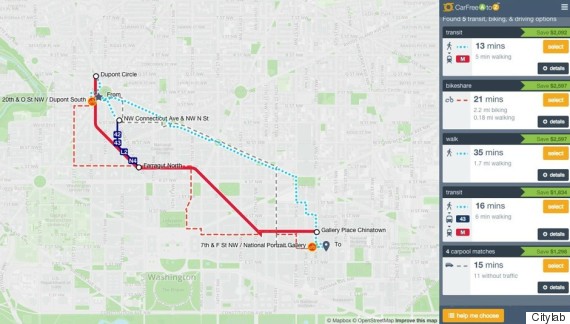
It’s a notch above Google Maps.
Hamilton describes CarFreeAtoZ as a step up from the likes of Google Maps when it comes to route configuration. Instead of limiting users to a single mode from door to door, CarFreeAtoZ can combine alternatives into one trip itinerary. Let’s say you make regular trips from Dupont Circle to Verizon Center in Chinatown. CarFreeAtoZ shows you a Metro option, a Capital Bikeshare option, an all-walking option, or a bus to subway route:
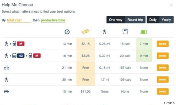
Users can decide if they’re making plans for a one-way or round trip, and if they just need help for the day or want to plan a new commute habit. They can also sort their options by five factors: travel time, walking distance, exercise, productivity time, and cost. The tool makes these comparisons based on a drive, says Hamilton, with the cost estimates taking into account fuel prices and downtown parking rates. Here’s the Dupont–Verizon Center comparison:
Arlington staffers will be sending car-free teams into the community beginning this summer to teach locals about the tool. But the basic CarFreeAtoZ site might be a hard sell for someone who isn’t already interested in making the shift to an alternative mode. Research shows that people are pretty dead set in their commuting ways—to the point where they can’t be considered choices so much as reflexes.
There are certain periods when people do seem most vulnerable to a travel mode shift: during major life events, such as moving to a new home or getting a new job. It’s these moments when CarFreeAtoZ can be especially useful, says Conveyal’s David Emory. He foresees new Arlington residents receiving a welcome-to-the-neighborhood packet that includes a CarFreeAtoZ URL pre-populated with the person’s address—a well-timed nudge toward a car-free option.
“You're definitely more likely to reassess your behavior when given a trigger like that, as opposed to just doing it out of the blue,” he says. “It's a combination of targeting people at the right times, articulating the benefits in a compelling way, and giving employers and organizations—even housing communities—a way to incentivize that change.”
Businesses can even use it to relocate.
The current CarFreeAtoZ site is tailored toward individual commuters. But Conveyal says it’s working on back-end components that can help employers make transit-friendly workplace locations. Take Marriott, which recently announced that it wanted to leave its car-centric suburban Bethesda headquarters because “it’s essential we be accessible to Metro,” as chief executive Arne M. Sorenson told the Washington Post, largely to become a workplace that’s attractive to Millennials: “… I think as with many other things our younger folks are more inclined to be Metro-accessible and more urban. That doesn’t necessarily mean we will move to downtown Washington, but we will move someplace.”
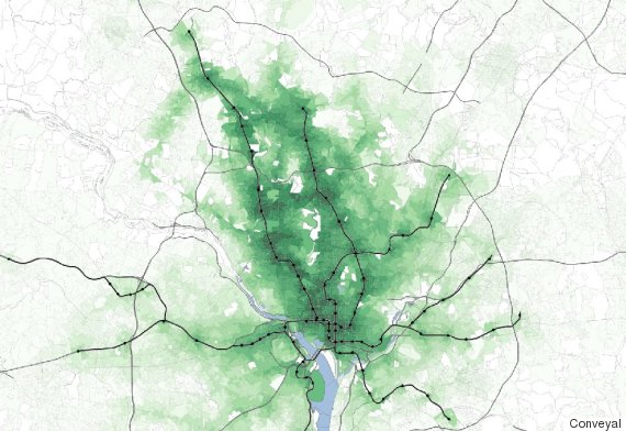
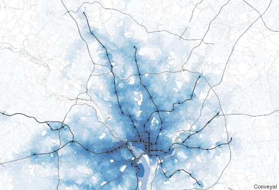
Using the types of tools that Conveyal is developing on a wider scale, Emory mapped out some possible transit-friendly relocation options for Marriott. The map below show’s the company’s possible “transit shed”—areas its current 2,000 employees can reach by walking and public transportation alone. The darker the shade of green, the shorter the travel time. In the darkest spots, up to 40 percent can make the trip via transit, up from 10 percent today.
And if Marriott were to consider its transit shed beyond the current workforce, to all potential workers in the metro D.C. area, the car-free possibilities become even greater:
Emory says these efforts build on emerging evidence showing the business benefits of locating near good public transportation. And the more involved a company gets with these tools, the more car-free options will materialize. Emory envisions a scenario where Conveyal can run an analysis of an employee database and recommend carpools based on employee addresses. It can also provide employers with metrics to track how much car-free decisions save them on parking costs.
For now, says Emory, the based CarFreeAtoZ interface likely won’t change, even as the employer-centric tools develop. The program partners are currently looking to expand into other cities in Virginia, and Emory says they’d like to have a national impact eventually. Because the tool is an open-source project, any city or transportation agency can build on the work already being done—perhaps as part of a broad government effort to reduce drive-alone commuting.
“The tool's got very powerful planning aspects,” says Hamilton. “A transit agency could use it, a planning agency could use it, and a company could use it to help them make decisions.”