
The maps. It was initially all about the maps. But it is geography that unites and divides.
As we began our journey with Honor the Earth to check out the proposed route of the Enbridge Sandpiper Pipeline through the Great Plains of North Dakota, we picked up US 2 in northwestern Minnesota. What Longfellow might call the remnants of the "forest primeval" hugged the gently rolling roadside -- a curtain of larch, cedar and black spruce reminding us what the Lakota and European fur traders faced as they pursued their trade routes. When the road took a slight turn north through Crookston, the blanket of forest receded and the Red River Valley welcomed us to North Dakota and expanses of flat fertile farmland stretching to the horizon. Along the way the highway hugs abandoned towns and municipalities, reservoirs, state and national parks, First Nation reservations, wildlife refuges, the National Grasslands and the Bakken oil fields before the road becomes an afterthought in Williston. BNSF trains replaced the protective wall of forest, a constant reminder of the cargo they hauled and what Enbridge was eager to transport through the new pipeline.
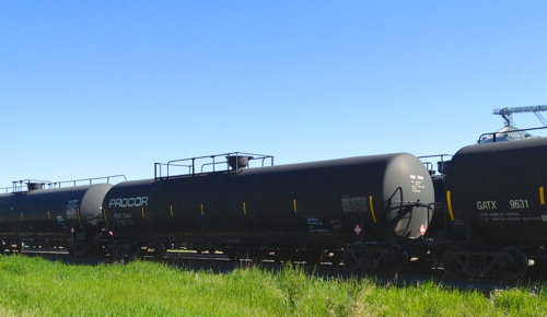
Hauling crude on the plains (Photo: G. Nienaber)
The North Dakota Department of Mineral Resources reported last week that the state, home to booming oil production in the Bakken formation, became the fourth state in U.S. history to produce more than 1 million barrels of oil a day.
When the North Dakota Pipeline Company, a subsidiary of Enbridge Energy Partners, announced plans to build the Sandpiper Pipeline Project, activists in Minnesota sat up and took notice. Enbridge is a Canadian company and operates 15,795 miles of crude oil pipelines in North America.
There are 66.6 people per square mile in Minnesota, compared to 9.7 in North Dakota.
Minnesotans are very particular about their land of 10,000 lakes. North Dakota has the prairie potholes, a critical habitat for continental waterfowl breeding, but 4.1 million breeding ducks don't have much of a voice in local government.
North Dakota also has one of the largest freshwater lakes in the country, Lake Sakakawea, which was created behind a dam built in the 1940s on the Missouri River. The Northern Great Plains Aquifer System covers approximately 300,000 square miles. This aquifer system lies underneath nearly all of North and South Dakota, as well as half of Montana. It also covers nearly one third of the state of Wyoming. The Williston Basin aquifer covers much of Montana, North Dakota, South Dakota and some parts of Canada.
That is a lot of water, but water is not a renewable resource. Much is being used in the fracking industry and parts of the watershed are under threat of contamination by oil spills if a pipeline happens to run through it. No one knows what happens when fracking wastewater is injected into deep wells under the aquifer for disposal, but the USGS recently issued a statement that warned against earthquake swarms in fracking areas. But no fracking means no oil.
The new Sandpiper Pipeline, if approved, will be 616 miles long, 24 inches in diameter and run from Enbridge's Beaver Lodge station, south of Tioga, North Dakota to Clearbrook, MN. From there the pipeline would increase to 30 inches and deliver its cargo of Bakken crude to refineries in Superior, Wisconsin.
The Minneapolis Star Tribune published an article on an obscure pipeline spill near Bemidji, MN. In August 1979 a high-pressure 34-inch Enbridge pipeline ruptured, spilling 10,500 barrels equaling 450,000 gallons of crude. 35 years later, 100,000 gallons remain and the best anyone can do is research the effects.
But how can the public react if they have no information?
Is North Dakota experiencing a culture of silence or a culture of ignorance?
The initial Enbridge maps of North Dakota were little more than county outlines; 21 pages in a PDF file that was indecipherable. There were no county roads, only minimal water features and no sense of how the proposed routing would impact existing infrastructure. After two days on the road, and many requests through press offices, field offices and the media hotline, we received maps that were as detailed as the Minnesota maps that were available on the web. Enbridge was helpful in that regard, but GIS readings are impossible to obtain, and much detail is still unavailable on the maps.
Enbridge had obtained an order that restricts the exact pipeline location as "Critical Energy Infrastructure Information," protected under the 2011 Patriot Act.
This begs the question as to how a non-existent pipeline can be protected as critical energy infrastructure. Enbridge states on its website that the Sandpiper will "generally follow Enbridge's existing pipelines and/or other infrastructure right-of-way. More than 75 percent of the route is on existing utility right-of-way." The mile markers for the existing Line 81 are clearly visible along Highway 2. Why not offer the GIS coordinates for the remaining 25 percent?
Lakota was the first stop on our pipeline tour. Lakota is the county seat of Nelson County, located 63 miles west of Grand Forks and 27 miles east of Devils Lake. The population of Lakota was 672 at the 2010 census. The total population of Lakota County was 3,126, all scattered over 1,009 square miles.
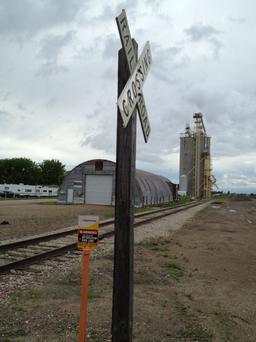
Photo: G. Nienaber
We stopped at the courthouse after a courtesy call and found that staff had no maps and no information on the proposed pipeline. We noticed a mile marker (147) for the existing Line 81 on the outskirts of town. The only other available information was the minutes from a Planning Commission meeting on January 30, 2014. Five commission members were present for a discussion on the route of the pipeline and a new pump station in Dodds Township. In case of a leak,the addition of a retention pond at the pump station was also discussed.
Who else was at the meeting? Seven people from Enbridge, including the point person for the project who provided our maps. No locals were present, according to the minutes. The zoning change for the proposed pump station was unanimously approved.
Does anyone go to Planning Commission meetings in rural areas? We went to the local café to find out.
The Seasons Café occupies the old Farmer's Mercantile building in Lakota. The railroad, Russians and Germans built the town. By the time the railroad was completed in 1883, the buffalo were long gone and the 1851 Fort Laramie Treaty had squeezed the First Nation from ancestral lands. It looks like the town that time forgot; all but lost in the tall prairie grasses.
Now the rail hauls Bakken crude in aging DOT 111 tanker cars roaring right through the center of town. The Association of American Railroads (AAR) says 92,000 tank cars are moving flammable liquids and approximately 78,000 of those will require retrofitting or phase-out. The 14,000 newer tank cars that comply with higher industry-imposed safety standards from 2011 also might require some upgrades.
There were only a few people having lunch, but they had more questions than answers for us. What pipeline? Comments centered on the increase in trains, the noise and the number of cars hauling oil. No one had seen a map and the news of a pipeline was fodder for conversation. Had anyone heard about the series of meetings scheduled last winter by the North Dakota Public Services Commission about the Sandpiper route?
No.
Perhaps the fact that North Dakota experienced one of the worst winters on record had something to do with the lack of attendance. Meetings were scheduled in Grand Forks, Devils Lake and Minot in late February. Many residents would have to travel hundreds of miles to attend meetings. Darkness comes early on winter nights in the Great Plains. Roads are hazardous, ice covered and farms and animals need attending. Enbridge was following the letter of the law about public hearings, but no one seemed to be getting the message.
So we packed up and headed west again, following the rail line and Enbridge Line 81.
It was a late spring, the corn was six inches high at most and a few deer were browsing in the furrows. We would detour south on County 4 to check out the Larimore Dam and Recreation Area that sits two miles from the proposed pipeline.
The Larimore Dam is a 66.7-acre reservoir on the upper Turtle River in Grand Forks County. Its watershed encompasses 41,344 acres -- protected waters under the hopefully watchful eye of the EPA and the Army Corps of Engineers.
Line 81 had a small spill near Grand Forks in 2013. The company said less than ten gallons leaked, but Line 81 and its cargo of 210,00 barrels per day was shut down as a precaution while more pressure tests were done. It was a small leak compared to the rupture of Line 6B in Kalamazoo Michigan in 2010. 20,500 barrels polluted the waterway, and cleanup is still not completed.
After a call to the County Recorder's Office we decided to veer north on 281 and check out Cando. Cando is the county seat of Towner County. Founded in 1884, the population was 1,115 at the 2010 census. The story was the same there as it was in Lakota, but by the time we reached Cando, we had a map to offer to puzzled county officials who had absolutely no idea where the proposed Sandpiper would run. The newspaper of record, The Towner County Record Herald, was also in the dark. It is s strange feeling to be a writer going to the first source of information, the local newspaper, only to find out you know more than the staff.
And so it went until we reached Minot. On the way we drove right over the Geographic Center of North America, but were too focused on our maps to notice.
We came away from our journey through the small towns of the northern Great Plains with a better sense of history and a vanishing legacy of European settlers. It was only on First Nation reservations that we sensed awareness, but hopelessness seemed to feed on the knowledge that something big and unstoppable was happening.
"We woke up and we realized we lost it." (Fort Berthold Elder)
Are we being devoured by our hunger for cheap power? Are oil companies using a new embodiment of Manifest Destiny on the Great Plains?
When Sakakawea joined the Lewis and Clark expedition and offered her knowledge of trading routes, she opened the doorway to the West. Settlers arrived, so did smallpox and the Mandan and Hidatsa were forced to abandon their ancestral homelands. The broken Fort Laramie treaty forced a final move by the tribes to the Fort Berthold Reservation with their allies the Arikara.
Are we collectively opening the door to unbridled oil exploration when we do not question intent or at the very least demand information on infrastructure? Are we a generation of unwitting guides, leading the way to the destruction of our culture and way of life?
Next: What happened at Knife River -- A Cautionary Tale
Special thanks to Alyssa Hoppe of Honor the Earth
Longer Article Cross post at LAProgressive