In terms of physical size, Canada is the second largest country in the world behind only Russia. But most of its 35 million people live in a very small area.
To see just how small, follow the series of maps below.
Where do Canada's people live? (size = population)
This is a cartogram, a map in which the area of each region is substituted with some mapping variable, population in this case. Said another way, the size of each region corresponds to the number of people who live there.
Canada gets deformed to the point it's completely unrecognizable (for comparison, see these cartograms of the U.S. and the U.K., which largely retain their basic shape).
The bulk of the cartogram's area, and therefore Canada's population, is in the bulge on the right. And that bulge is predominantly made up of just three light-colored regions and their immediate surroundings: Toronto, Montreal, and Ottawa, Canada's 1st, 2nd, and 4th most populous metro areas respectively.
A full half of Canada's population lives here.
This region covers an area of roughly 50,000 square miles (about the same size as Pennsylvania). And all of it is located south of the Washington-Oregon border.
Half of Canada's people (red) live south of the Washington-Oregon border
This next cartogram is the same as the one at the top, except this one has only two colored regions. Half of Canada lives in the red, half lives in the grey.
Credit to reddit user Machetegun / Brilliant Maps for "50% of Canadians Live South of This Line" map
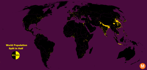
To see how the unevenness of Canada's population compares with other places in the world, see: The Nordics, Northern Africa, India, Spain, Tokyo, The World
This post originally appeared on Metrocosm