It's about one week into our kayak journey down the Colorado River, and we're walking along a highway. Record heat, record drought. Half the state is up in flames and the river we're supposed to be following is nowhere in sight. We walk along the asphalt shoulder, looking to where the sagebrush and yellowing grass on the hillsides meets the rich green and purple of the irrigated alfalfa fields below. The only relief we get from sun's relentlessness comes from the quick blasts of breeze that ride on the tails of each passing semi-truck.
We're walking towards the town of Hot Sulphur Springs from Lake Granby where we last saw the river. Why aren't we floating downstream as the title of our expedition, Down the Colorado, seems to promise? There are several reasons. First, we've reached what's known locally as the "hole in the river." After the Granby Dam, the river shrinks in size. Some 60 percent of the water is corralled from the upper Colorado and its tributaries and directed to the Front Range through a series of canals, pumps, tunnels, reservoirs and siphons. With this season's low run-off, the remaining water below Lake Granby is incapable of floating our tiny inflatable rafts.
We also don't want to be caught trespassing. Unlike other states such as Idaho where both the river and its bed belong to the public, Colorado's law dictates that only the river's water is fair game for kayakers. Property owners can't persecute boaters who float past their land, but if you so much as scrape a submerged rock or get out to portage around a barbed wire fence, you enter an intimidating gray area in the law. Kayaking lore is rich with stories of boaters being driven away from some menacing rapid by an armed and irate landowner, but, like fishermen, kayakers are well-known for their tendency to exaggerate.
Nevertheless, when given the choice between a possible run in with a shotgun or sheriff on the river and the eating of exhaust on the highway, we lean towards the latter, although our fears are probably as exaggerated as the stories. All the landowners we've actually met along the way have been supportive of our journey and their generosity has been exceptional. At Grand Lake, for example, we received not only the permission to float a section of river through private property, but we were invited to spend the night as well. All we had to do was ask. But below Granby we don't know who to ask; so we end up walking.
After eight miles, we reach Windy Gap Reservoir where we meet up with Rob Firth, the Colorado River Headwaters Project Coordinator for Trout Unlimited. He informs us that the full-fledged "hole in the river" begins at Windy Gap and ends where Troublesome Creek reinvigorates the river's flow 21 miles downstream. According to Firth, this stretch is "a terribly dewatered section that puts this river in a very perilous state." He explains the situation to us as we head downstream to see more:
At Windy Gap, Northern Water Conservancy District (a regional water supplier for the Front Range) diverts to 800,000 people between Boulder and Fort Collins. Denver Water has already diverted much of the Fraser River, which joins the Colorado just upstream of Windy Gap. Although Denver and Northern are required to provide a certain amount of flow to senior water rights holders on the mainstem of the Colorado -- namely the Shoshone hydropower plant near Glenwood Springs and the canals that irrigate the Grand Junction area -- the two water suppliers can do a lot of shuffling in where they release the water to meet these deliveries. Drawing from a system of reservoirs on the Blue River, Williams Fork and other tributaries, Denver and Northern can pump much of the upper Colorado across the continental divide and then return the required flows lower down on the river. The section between the last pumping station and where water is put back into river is considered the "hole."
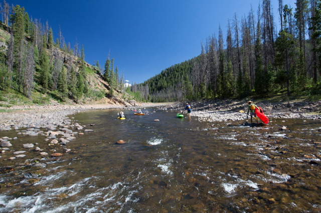
When we cross the Colorado River a few miles down, it looks as if it should be called the Colorado Creek instead. It's clear, warm, and very shallow. Reduced flows are threatening this Gold Medal Trout stream and the broader riparian habitat.
We see a black bear cross the stream several times, perhaps trying to find some relief from the day's heat. Firth, a former game warden, speculates on the bear's curious behavior and tells us that Trout Unlimited's goal isn't simply to maintain quality fishing in the area; it's also to protect the ecosystem as a whole, from the insects to the bears. "If you can keep trout at a healthy level, being kind of the top of the food chain, then everything beneath then has to exist in harmony." Unfortunately, the "hole" is experiencing an unnatural warming of the shallow water, threatening the insect populations that trout and other fish depend on. According to Firth, "38 percent of the macroinvertebrates species have disappeared from this river since they've turned on Windy Gap Dam in 1985." 
Firth is concerned with the Windy Gap and Moffat firming projects, proposals from Denver and Northern that would divert as much as 80 percent of the river's flow out of the Colorado. "The river reaches a tipping point," Firth says, "where it no longer means one more bucket out means one more bug out. You may reach a point where one more bucket out means everything crashes and you may no longer have a viable trout fishery." To help mitigate the effects of the proposed projects, Trout Unlimited and local landowners are encouraging diverters to take several courses of action. First, the river needs adequate flows through the "hole." If only a fraction of the historical flow is still available, they're asking for a deepening of the river channels in high-risk sections to keep water cooler. They also are advocating for regular flushing flows that will mimic natural flood events. Finally, they're requesting a bypass channel be built around Windy Gap Dam that would allow connectivity with the less damaged ecosystem upstream. Both the proposals and what mitigation will be required by Denver and Northern remain under discussion.
When we reach Hot Sulphur Springs, we're able to get back in our boats. The river is still too shallow to float without scraping ground, but Firth has kindly called every landowner between Hot Sulphur and Kremmling, securing permission for our safe passage. We spend two more days bumping along before we pass the Williams Fork and Blue Rivers. For the first time since the river's source, have enough water to attract other boaters, people with a less insane idea of what constitutes a floatable river. We're happy to have made it out of the "hole."
That night, we camp near the gates of Gore Canyon where the Colorado ceases meandering through flat ranch lands and cuts directly into the jagged Gore Range. The mosquitoes are so thick we eat dinner in the tents. Smoke from wildfires to the west enriches the red haze at sunset. Red light lingers over the menacing notch in the mountains, looking like something out of Middle Earth. Tomorrow we will enter that canyon to tackle what may be the highest quality Class V rapids on the entire Colorado River.
Visit www.downthecolorado.org to follow the expedition.