Thanks to heavy rains from a slow-moving cold front, the massive drought affecting the U.S. receded slightly during the past week, as the drought footprint for all drought categories fell between Sept. 25 and Oct. 2. The findings, contained in the latest U.S. Drought Monitor, were released Thursday.
As of Oct. 2, about 65 percent of the contiguous U.S. experienced some form of drought, down a smidgen from 65.45 percent one week ago. The biggest drop occurred in the area of the lower 48 states experiencing severe to exceptional drought conditions, which went from 42.1 percent on Sept. 25 to 40.1 percent as of October 2.
The drought footprint as of Sept. 25 had set a record in the 12-year history of the Drought Monitor.
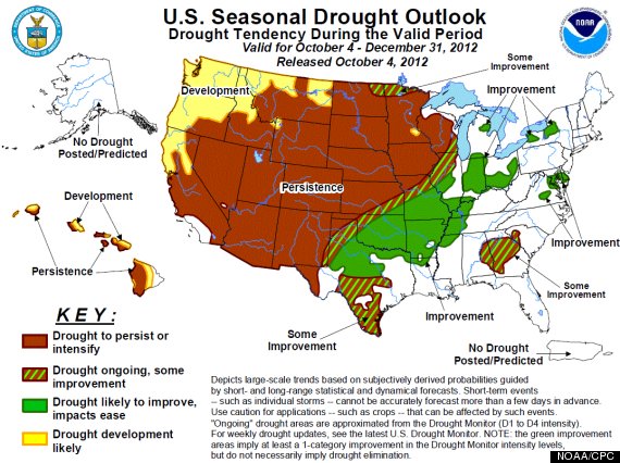
The U.S. Seasonal Drought Outlook valid through December 31, 2012. Click on the image for a larger version.
The beneficial rainfall fell across the southern Plains, lower Mississippi Valley, and the interior Southeast. Heavy rain also fell over the Ohio and Tennessee Valleys, southern Illinois, eastern Missouri, and the interior mid-Atlantic region, according to the National Weather Service.
Drought conditions improved in states such as Georgia, Illinois, Missouri, Oklahoma, and Texas. In Texas, which suffered its worst drought on record in 2011 and has continued to be mired in drought conditions, the area of the state in moderate drought or worse dropped to 65.97 percent from 78.7 percent on Sept. 25. The Climate Prediction Center, part of the National Oceanic and Atmospheric Administration (NOAA), reported that west-central Texas saw its first significant river runoff in more than two years.
Drought conditions loosened their grip on two more of the hardest-hit drought states as well, with the worst drought categories receding in Oklahoma and Georgia. In Georgia, the area in exceptional drought dropped from 17.18 percent on Sept. 25 to just 9.03 percent.
At the same time as some saw improvement, conditions worsened in the Dakotas, Minnesota, Nebraska, Wisconsin, and Wyoming.
Nebraska remains the state with the highest proportion of exceptional drought, which is the worst drought category. Exceptional drought now covers a vast majority — 77.61 percent — of the state, up from 73.25 percent on Sept. 25.
Exceptional drought also expanded significantly in South Dakota, jumping from 6.72 percent to 27 percent. In North Dakota, severe drought conditions increased from 28.49 percent to 51 percent.
The drought is the worst such event to strike the U.S. since the 1950s and is comparable in some ways to the “Dust Bowl” era droughts of the 1930s. While the drought was most likely triggered by a particular pattern of ocean temperatures in the Pacific and Atlantic Oceans, it was likely aggravated by extreme heat this summer. July was the warmest month of any month on record, and the summer was the third-warmest on record. Climate studies have shown that the odds of severe heat waves are increasing due to manmade climate change.
According to the latest Seasonal Drought Outlook, also released Thursday, drought conditions are likely to persist through December to the west of a line from Illinois southwestward to west Texas. This means that the northern Plains, Rocky Mountain States, Pacific Northwest, and Desert Southwest are all likely to be impacted by drought persisting conditions — or possibly even worsening — through December 31.
Drought conditions are forecast to improve during the period in the lower Mississippi River Valley, much of Texas, Ohio Valley, Georgia, and the Mid-Atlantic states.
The drought outlook is based on climate forecasts that reflect the potential effects from a developing weak El Niño event in the Pacific Ocean. Such events tend to produce above average winter precipitation across the nation’s southern tier and Ohio Valley, while leaving the Pacific Northwest drier than average.
In recent weeks, signs of the developing El Niño have become more muted, casting doubt on whether it will actually take shape, and if so, how strong it might be. The fate of the El Niño will have a major impact on the prevailing winter weather pattern across the U.S.
The drought outlooks released during the spring of 2012 failed to forecast the dramatic expansion and intensification of the drought conditions. Although some computer models correctly anticipated a hot and dry summer, official outlooks did not provide early warning as to the size and severity of the drought event.
Some computer models, did capture both the drought and heat well in advance, but these were outlier predictions that were discounted in favor of the consensus view from many other models.

